You are here: Home > Network List > TA - USArray Transportable Network (new EarthScope stations) Stations List
> Station C27K Jago River, AK, USA > Earthquake Result Viewer
C27K Jago River, AK, USA - Earthquake Result Viewer
| Earthquake location: |
Vanuatu Islands |
| Earthquake latitude/longitude: |
-19.0/169.5 |
| Earthquake time(UTC): |
2019/10/21 (294) 02:52:29 GMT |
| Earthquake Depth: |
226 km |
| Earthquake Magnitude: |
6.4 Mww |
| Earthquake Catalog/Contributor: |
NEIC PDE/us |
|
| Network: |
TA USArray Transportable Network (new EarthScope stations) |
| Station: |
C27K Jago River, AK, USA |
| Lat/Lon: |
69.63 N/143.71 W |
| Elevation: |
392 m |
|
| Distance: |
94.4 deg |
| Az: |
14.845 deg |
| Baz: |
223.792 deg |
| Ray Param: |
0.04086788 |
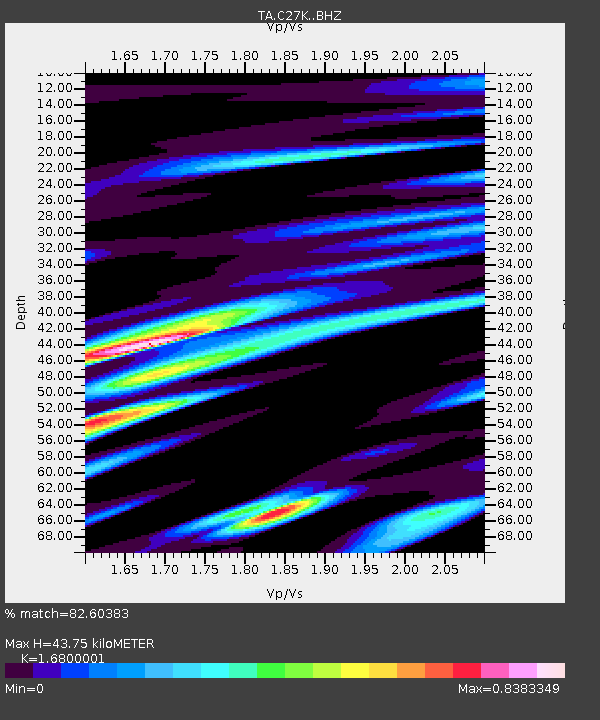
| Estimated Moho Depth: |
43.75 km |
| Estimated Crust Vp/Vs: |
1.68 |
| Assumed Crust Vp: |
6.522 km/s |
| Estimated Crust Vs: |
3.882 km/s |
| Estimated Crust Poisson's Ratio: |
0.23 |
|
| Radial Match: |
82.60383 % |
| Radial Bump: |
392 |
| Transverse Match: |
78.55752 % |
| Transverse Bump: |
357 |
| SOD ConfigId: |
19951751 |
| Insert Time: |
2019-11-04 03:03:48.304 +0000 |
| GWidth: |
2.5 |
| Max Bumps: |
400 |
| Tol: |
0.001 |
|

Signal To Noise
| Channel | StoN | STA | LTA |
| TA:C27K: :BHZ:20191021T03:04:51.899974Z | 12.4975195 | 2.788918E-6 | 2.2315773E-7 |
| TA:C27K: :BHN:20191021T03:04:51.899974Z | 5.063321 | 1.0162092E-6 | 2.0070014E-7 |
| TA:C27K: :BHE:20191021T03:04:51.899974Z | 3.318349 | 5.805796E-7 | 1.7496038E-7 |
| Arrivals |
| Ps | 4.7 SECOND |
| PpPs | 18 SECOND |
| PsPs/PpSs | 22 SECOND |


