You are here: Home > Network List > TA - USArray Transportable Network (new EarthScope stations) Stations List
> Station J14K Nanvaranak Lake, AK, USA > Earthquake Result Viewer
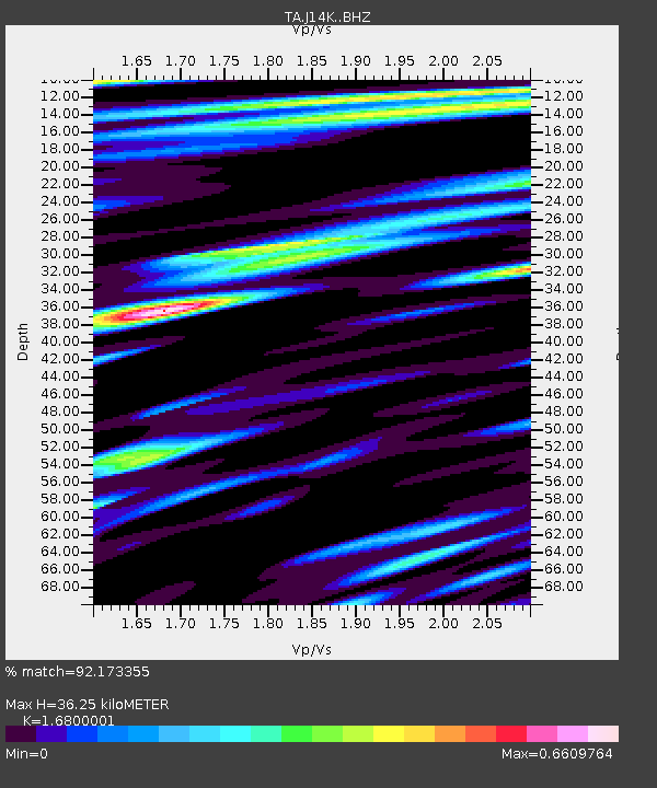
J14K Nanvaranak Lake, AK, USA - Earthquake Result Viewer
| Earthquake location: |
Vanuatu Islands |
| Earthquake latitude/longitude: |
-19.0/169.5 |
| Earthquake time(UTC): |
2019/10/21 (294) 02:52:29 GMT |
| Earthquake Depth: |
226 km |
| Earthquake Magnitude: |
6.4 Mww |
| Earthquake Catalog/Contributor: |
NEIC PDE/us |
|
| Network: |
TA USArray Transportable Network (new EarthScope stations) |
| Station: |
J14K Nanvaranak Lake, AK, USA |
| Lat/Lon: |
62.75 N/163.55 W |
| Elevation: |
25 m |
|
| Distance: |
84.3 deg |
| Az: |
12.122 deg |
| Baz: |
205.564 deg |
| Ray Param: |
0.045058947 |
| Estimated Moho Depth: |
36.25 km |
| Estimated Crust Vp/Vs: |
1.68 |
| Assumed Crust Vp: |
6.155 km/s |
| Estimated Crust Vs: |
3.664 km/s |
| Estimated Crust Poisson's Ratio: |
0.23 |
|
| Radial Match: |
92.173355 % |
| Radial Bump: |
345 |
| Transverse Match: |
86.66603 % |
| Transverse Bump: |
397 |
| SOD ConfigId: |
19951751 |
| Insert Time: |
2019-11-04 03:04:27.523 +0000 |
| GWidth: |
2.5 |
| Max Bumps: |
400 |
| Tol: |
0.001 |
|

Signal To Noise
| Channel | StoN | STA | LTA |
| TA:J14K: :BHZ:20191021T03:04:04.12501Z | 53.247902 | 8.681169E-6 | 1.6303306E-7 |
| TA:J14K: :BHN:20191021T03:04:04.12501Z | 17.628405 | 2.4129351E-6 | 1.3687769E-7 |
| TA:J14K: :BHE:20191021T03:04:04.12501Z | 8.976555 | 1.4546305E-6 | 1.6204775E-7 |
| Arrivals |
| Ps | 4.1 SECOND |
| PpPs | 15 SECOND |
| PsPs/PpSs | 20 SECOND |


