You are here: Home > Network List > IU - Global Seismograph Network (GSN - IRIS/USGS) Stations List
> Station CTAO Charters Towers, Australia > Earthquake Result Viewer
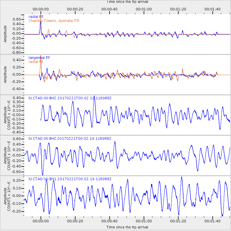
CTAO Charters Towers, Australia - Earthquake Result Viewer
*The percent match for this event was below the threshold and hence no stack was calculated.
| Earthquake location: |
Fiji Islands Region |
| Earthquake latitude/longitude: |
-15.0/-176.4 |
| Earthquake time(UTC): |
2017/02/20 (051) 23:55:48 GMT |
| Earthquake Depth: |
6.0 km |
| Earthquake Magnitude: |
5.5 Mww |
| Earthquake Catalog/Contributor: |
NEIC PDE/us |
|
| Network: |
IU Global Seismograph Network (GSN - IRIS/USGS) |
| Station: |
CTAO Charters Towers, Australia |
| Lat/Lon: |
20.09 S/146.25 E |
| Elevation: |
357 m |
|
| Distance: |
35.9 deg |
| Az: |
256.387 deg |
| Baz: |
87.96 deg |
| Ray Param: |
$rayparam |
*The percent match for this event was below the threshold and hence was not used in the summary stack. |
|
| Radial Match: |
59.50525 % |
| Radial Bump: |
334 |
| Transverse Match: |
52.612053 % |
| Transverse Bump: |
400 |
| SOD ConfigId: |
1992691 |
| Insert Time: |
2017-03-06 23:59:12.753 +0000 |
| GWidth: |
2.5 |
| Max Bumps: |
400 |
| Tol: |
0.001 |
|
Signal To Noise
| Channel | StoN | STA | LTA |
| IU:CTAO:00:BHZ:20170221T00:02:19.118988Z | 3.0096977 | 3.7533434E-7 | 1.2470832E-7 |
| IU:CTAO:00:BH1:20170221T00:02:19.118988Z | 1.3752465 | 1.2418721E-7 | 9.0301775E-8 |
| IU:CTAO:00:BH2:20170221T00:02:19.118988Z | 1.5138406 | 2.1411985E-7 | 1.4144148E-7 |
| Arrivals |
| Ps | |
| PpPs | |
| PsPs/PpSs | |


