You are here: Home > Network List > TA - USArray Transportable Network (new EarthScope stations) Stations List
> Station O17K Koliganek, Bristol Bay, AK, USA > Earthquake Result Viewer
O17K Koliganek, Bristol Bay, AK, USA - Earthquake Result Viewer
| Earthquake location: |
Vanuatu Islands |
| Earthquake latitude/longitude: |
-19.0/169.5 |
| Earthquake time(UTC): |
2019/10/21 (294) 02:52:29 GMT |
| Earthquake Depth: |
226 km |
| Earthquake Magnitude: |
6.4 Mww |
| Earthquake Catalog/Contributor: |
NEIC PDE/us |
|
| Network: |
TA USArray Transportable Network (new EarthScope stations) |
| Station: |
O17K Koliganek, Bristol Bay, AK, USA |
| Lat/Lon: |
59.77 N/157.09 W |
| Elevation: |
156 m |
|
| Distance: |
83.1 deg |
| Az: |
16.315 deg |
| Baz: |
211.684 deg |
| Ray Param: |
0.045844384 |
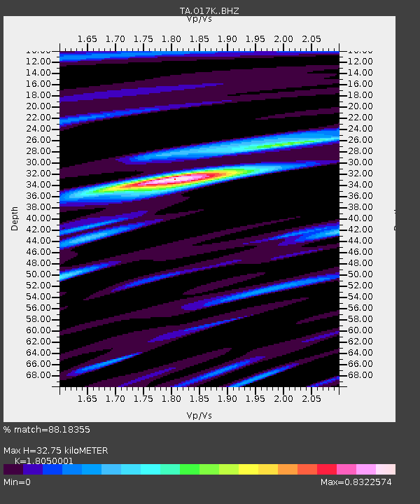
| Estimated Moho Depth: |
32.75 km |
| Estimated Crust Vp/Vs: |
1.81 |
| Assumed Crust Vp: |
6.276 km/s |
| Estimated Crust Vs: |
3.477 km/s |
| Estimated Crust Poisson's Ratio: |
0.28 |
|
| Radial Match: |
88.18355 % |
| Radial Bump: |
400 |
| Transverse Match: |
83.77361 % |
| Transverse Bump: |
400 |
| SOD ConfigId: |
19951751 |
| Insert Time: |
2019-11-04 03:04:50.778 +0000 |
| GWidth: |
2.5 |
| Max Bumps: |
400 |
| Tol: |
0.001 |
|
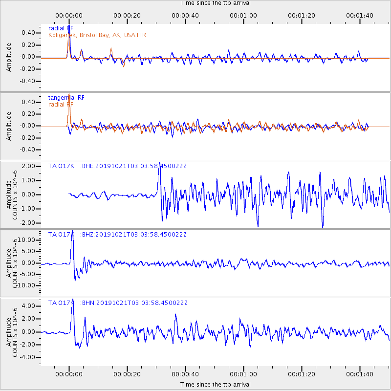
Signal To Noise
| Channel | StoN | STA | LTA |
| TA:O17K: :BHZ:20191021T03:03:58.450022Z | 43.13298 | 5.785665E-6 | 1.3413553E-7 |
| TA:O17K: :BHN:20191021T03:03:58.450022Z | 18.497389 | 2.169145E-6 | 1.1726763E-7 |
| TA:O17K: :BHE:20191021T03:03:58.450022Z | 9.350151 | 1.0238517E-6 | 1.09501094E-7 |
| Arrivals |
| Ps | 4.3 SECOND |
| PpPs | 14 SECOND |
| PsPs/PpSs | 19 SECOND |


