You are here: Home > Network List > TA - USArray Transportable Network (new EarthScope stations) Stations List
> Station P19K Oil Pt, AK, USA > Earthquake Result Viewer
P19K Oil Pt, AK, USA - Earthquake Result Viewer
| Earthquake location: |
Vanuatu Islands |
| Earthquake latitude/longitude: |
-19.0/169.5 |
| Earthquake time(UTC): |
2019/10/21 (294) 02:52:29 GMT |
| Earthquake Depth: |
226 km |
| Earthquake Magnitude: |
6.4 Mww |
| Earthquake Catalog/Contributor: |
NEIC PDE/us |
|
| Network: |
TA USArray Transportable Network (new EarthScope stations) |
| Station: |
P19K Oil Pt, AK, USA |
| Lat/Lon: |
59.65 N/153.23 W |
| Elevation: |
629 m |
|
| Distance: |
84.1 deg |
| Az: |
18.026 deg |
| Baz: |
215.204 deg |
| Ray Param: |
0.04516201 |
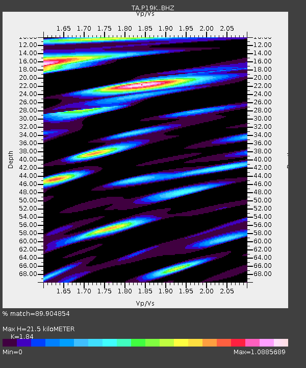
| Estimated Moho Depth: |
21.5 km |
| Estimated Crust Vp/Vs: |
1.84 |
| Assumed Crust Vp: |
5.989 km/s |
| Estimated Crust Vs: |
3.255 km/s |
| Estimated Crust Poisson's Ratio: |
0.29 |
|
| Radial Match: |
89.904854 % |
| Radial Bump: |
400 |
| Transverse Match: |
80.27783 % |
| Transverse Bump: |
400 |
| SOD ConfigId: |
19951751 |
| Insert Time: |
2019-11-04 03:04:57.297 +0000 |
| GWidth: |
2.5 |
| Max Bumps: |
400 |
| Tol: |
0.001 |
|

Signal To Noise
| Channel | StoN | STA | LTA |
| TA:P19K: :BHZ:20191021T03:04:03.399974Z | 38.1382 | 1.1949301E-5 | 3.133158E-7 |
| TA:P19K: :BHN:20191021T03:04:03.399974Z | 19.385557 | 6.3173165E-6 | 3.2587747E-7 |
| TA:P19K: :BHE:20191021T03:04:03.399974Z | 12.384771 | 3.825632E-6 | 3.0889808E-7 |
| Arrivals |
| Ps | 3.1 SECOND |
| PpPs | 10.0 SECOND |
| PsPs/PpSs | 13 SECOND |


