You are here: Home > Network List > TA - USArray Transportable Network (new EarthScope stations) Stations List
> Station Q16K King Salmon, AK, USA > Earthquake Result Viewer
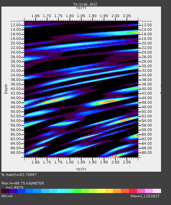
Q16K King Salmon, AK, USA - Earthquake Result Viewer
| Earthquake location: |
Vanuatu Islands |
| Earthquake latitude/longitude: |
-19.0/169.5 |
| Earthquake time(UTC): |
2019/10/21 (294) 02:52:29 GMT |
| Earthquake Depth: |
226 km |
| Earthquake Magnitude: |
6.4 Mww |
| Earthquake Catalog/Contributor: |
NEIC PDE/us |
|
| Network: |
TA USArray Transportable Network (new EarthScope stations) |
| Station: |
Q16K King Salmon, AK, USA |
| Lat/Lon: |
58.68 N/156.66 W |
| Elevation: |
22 m |
|
| Distance: |
82.3 deg |
| Az: |
17.094 deg |
| Baz: |
212.159 deg |
| Ray Param: |
0.046414584 |
| Estimated Moho Depth: |
69.75 km |
| Estimated Crust Vp/Vs: |
1.99 |
| Assumed Crust Vp: |
6.276 km/s |
| Estimated Crust Vs: |
3.158 km/s |
| Estimated Crust Poisson's Ratio: |
0.33 |
|
| Radial Match: |
92.78997 % |
| Radial Bump: |
400 |
| Transverse Match: |
94.44645 % |
| Transverse Bump: |
396 |
| SOD ConfigId: |
19951751 |
| Insert Time: |
2019-11-04 03:05:00.597 +0000 |
| GWidth: |
2.5 |
| Max Bumps: |
400 |
| Tol: |
0.001 |
|

Signal To Noise
| Channel | StoN | STA | LTA |
| TA:Q16K: :BHZ:20191021T03:03:54.299998Z | 77.96956 | 1.6624854E-5 | 2.1322235E-7 |
| TA:Q16K: :BHN:20191021T03:03:54.299998Z | 22.034853 | 8.863044E-6 | 4.0222844E-7 |
| TA:Q16K: :BHE:20191021T03:03:54.299998Z | 11.991579 | 4.7416333E-6 | 3.954136E-7 |
| Arrivals |
| Ps | 11 SECOND |
| PpPs | 32 SECOND |
| PsPs/PpSs | 44 SECOND |


