You are here: Home > Network List > TA - USArray Transportable Network (new EarthScope stations) Stations List
> Station Q20K Shuyak Island, AK, USA > Earthquake Result Viewer
Q20K Shuyak Island, AK, USA - Earthquake Result Viewer
| Earthquake location: |
Vanuatu Islands |
| Earthquake latitude/longitude: |
-19.0/169.5 |
| Earthquake time(UTC): |
2019/10/21 (294) 02:52:29 GMT |
| Earthquake Depth: |
226 km |
| Earthquake Magnitude: |
6.4 Mww |
| Earthquake Catalog/Contributor: |
NEIC PDE/us |
|
| Network: |
TA USArray Transportable Network (new EarthScope stations) |
| Station: |
Q20K Shuyak Island, AK, USA |
| Lat/Lon: |
58.61 N/152.39 W |
| Elevation: |
180 m |
|
| Distance: |
83.5 deg |
| Az: |
18.992 deg |
| Baz: |
216.026 deg |
| Ray Param: |
0.04558564 |
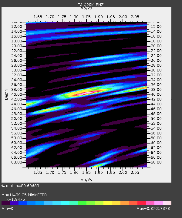
| Estimated Moho Depth: |
39.25 km |
| Estimated Crust Vp/Vs: |
1.85 |
| Assumed Crust Vp: |
5.989 km/s |
| Estimated Crust Vs: |
3.242 km/s |
| Estimated Crust Poisson's Ratio: |
0.29 |
|
| Radial Match: |
89.60683 % |
| Radial Bump: |
394 |
| Transverse Match: |
89.90197 % |
| Transverse Bump: |
400 |
| SOD ConfigId: |
19951751 |
| Insert Time: |
2019-11-04 03:05:01.605 +0000 |
| GWidth: |
2.5 |
| Max Bumps: |
400 |
| Tol: |
0.001 |
|

Signal To Noise
| Channel | StoN | STA | LTA |
| TA:Q20K: :BHZ:20191021T03:04:00.37501Z | 39.061176 | 9.90935E-6 | 2.5368797E-7 |
| TA:Q20K: :BHN:20191021T03:04:00.37501Z | 6.8611574 | 2.278828E-6 | 3.3213465E-7 |
| TA:Q20K: :BHE:20191021T03:04:00.37501Z | 9.278927 | 2.8474199E-6 | 3.068695E-7 |
| Arrivals |
| Ps | 5.7 SECOND |
| PpPs | 18 SECOND |
| PsPs/PpSs | 24 SECOND |


