You are here: Home > Network List > TA - USArray Transportable Network (new EarthScope stations) Stations List
> Station R33M Jennings River, BC, CAN > Earthquake Result Viewer
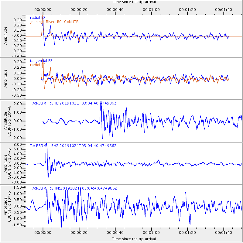
R33M Jennings River, BC, CAN - Earthquake Result Viewer
*The percent match for this event was below the threshold and hence no stack was calculated.
| Earthquake location: |
Vanuatu Islands |
| Earthquake latitude/longitude: |
-19.0/169.5 |
| Earthquake time(UTC): |
2019/10/21 (294) 02:52:29 GMT |
| Earthquake Depth: |
226 km |
| Earthquake Magnitude: |
6.4 Mww |
| Earthquake Catalog/Contributor: |
NEIC PDE/us |
|
| Network: |
TA USArray Transportable Network (new EarthScope stations) |
| Station: |
R33M Jennings River, BC, CAN |
| Lat/Lon: |
59.39 N/130.97 W |
| Elevation: |
1437 m |
|
| Distance: |
91.9 deg |
| Az: |
26.198 deg |
| Baz: |
234.706 deg |
| Ray Param: |
$rayparam |
*The percent match for this event was below the threshold and hence was not used in the summary stack. |
|
| Radial Match: |
77.624626 % |
| Radial Bump: |
304 |
| Transverse Match: |
78.062 % |
| Transverse Bump: |
320 |
| SOD ConfigId: |
19951751 |
| Insert Time: |
2019-11-04 03:05:04.797 +0000 |
| GWidth: |
2.5 |
| Max Bumps: |
400 |
| Tol: |
0.001 |
|
Signal To Noise
| Channel | StoN | STA | LTA |
| TA:R33M: :BHZ:20191021T03:04:40.474986Z | 10.895204 | 3.5143719E-6 | 3.2256136E-7 |
| TA:R33M: :BHN:20191021T03:04:40.474986Z | 1.9440591 | 6.7955375E-7 | 3.4955406E-7 |
| TA:R33M: :BHE:20191021T03:04:40.474986Z | 6.189007 | 1.0732525E-6 | 1.7341273E-7 |
| Arrivals |
| Ps | |
| PpPs | |
| PsPs/PpSs | |


