You are here: Home > Network List > TA - USArray Transportable Network (new EarthScope stations) Stations List
> Station L11A Cat Creek Ranch, Riddle, ID, USA > Earthquake Result Viewer
L11A Cat Creek Ranch, Riddle, ID, USA - Earthquake Result Viewer
| Earthquake location: |
Andreanof Islands, Aleutian Is. |
| Earthquake latitude/longitude: |
52.2/-175.7 |
| Earthquake time(UTC): |
2008/08/07 (220) 18:30:03 GMT |
| Earthquake Depth: |
12 km |
| Earthquake Magnitude: |
5.6 MB, 5.5 MS, 5.8 MW, 5.8 MW |
| Earthquake Catalog/Contributor: |
WHDF/NEIC |
|
| Network: |
TA USArray Transportable Network (new EarthScope stations) |
| Station: |
L11A Cat Creek Ranch, Riddle, ID, USA |
| Lat/Lon: |
42.17 N/115.75 W |
| Elevation: |
1511 m |
|
| Distance: |
40.8 deg |
| Az: |
79.613 deg |
| Baz: |
305.462 deg |
| Ray Param: |
0.074160986 |
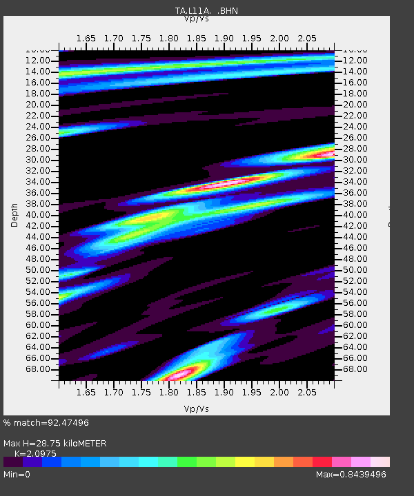
| Estimated Moho Depth: |
28.75 km |
| Estimated Crust Vp/Vs: |
2.10 |
| Assumed Crust Vp: |
6.291 km/s |
| Estimated Crust Vs: |
2.999 km/s |
| Estimated Crust Poisson's Ratio: |
0.35 |
|
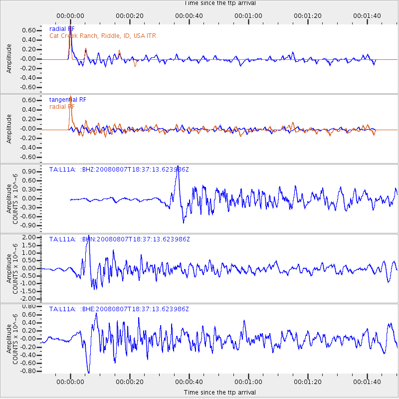
| Radial Match: |
92.47496 % |
| Radial Bump: |
397 |
| Transverse Match: |
80.64532 % |
| Transverse Bump: |
400 |
| SOD ConfigId: |
2504 |
| Insert Time: |
2010-03-07 05:07:54.294 +0000 |
| GWidth: |
2.5 |
| Max Bumps: |
400 |
| Tol: |
0.001 |
|
Signal To Noise
| Channel | StoN | STA | LTA |
| TA:L11A: :BHN:20080807T18:37:13.623986Z | 7.724584 | 3.1008068E-7 | 4.0142055E-8 |
| TA:L11A: :BHE:20080807T18:37:13.623986Z | 2.881346 | 1.161826E-7 | 4.0322334E-8 |
| TA:L11A: :BHZ:20080807T18:37:13.623986Z | 3.96593 | 1.4032749E-7 | 3.538325E-8 |
| Arrivals |
| Ps | 5.3 SECOND |
| PpPs | 13 SECOND |
| PsPs/PpSs | 19 SECOND |


