You are here: Home > Network List > US - United States National Seismic Network Stations List
> Station EGMT Eagleton, Montana, USA > Earthquake Result Viewer
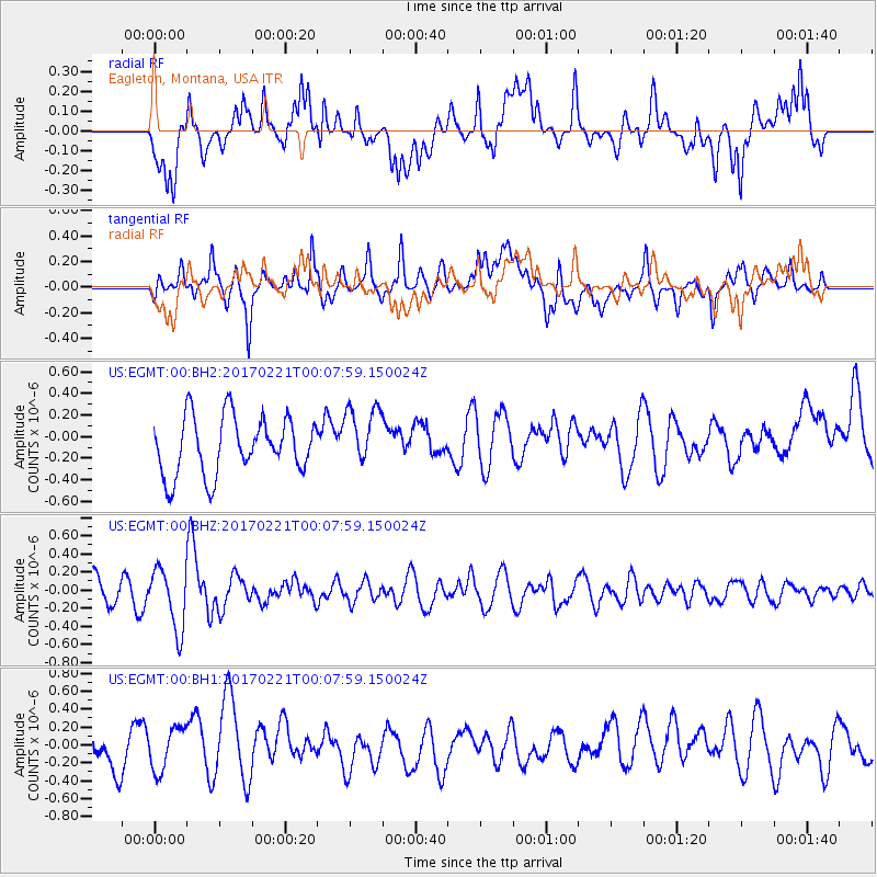
EGMT Eagleton, Montana, USA - Earthquake Result Viewer
*The percent match for this event was below the threshold and hence no stack was calculated.
| Earthquake location: |
Fiji Islands Region |
| Earthquake latitude/longitude: |
-15.0/-176.4 |
| Earthquake time(UTC): |
2017/02/20 (051) 23:55:48 GMT |
| Earthquake Depth: |
6.0 km |
| Earthquake Magnitude: |
5.5 Mww |
| Earthquake Catalog/Contributor: |
NEIC PDE/us |
|
| Network: |
US United States National Seismic Network |
| Station: |
EGMT Eagleton, Montana, USA |
| Lat/Lon: |
48.02 N/109.75 W |
| Elevation: |
1055 m |
|
| Distance: |
86.2 deg |
| Az: |
38.141 deg |
| Baz: |
242.767 deg |
| Ray Param: |
$rayparam |
*The percent match for this event was below the threshold and hence was not used in the summary stack. |
|
| Radial Match: |
50.88545 % |
| Radial Bump: |
400 |
| Transverse Match: |
47.990322 % |
| Transverse Bump: |
400 |
| SOD ConfigId: |
1992691 |
| Insert Time: |
2017-03-07 00:00:24.548 +0000 |
| GWidth: |
2.5 |
| Max Bumps: |
400 |
| Tol: |
0.001 |
|
Signal To Noise
| Channel | StoN | STA | LTA |
| US:EGMT:00:BHZ:20170221T00:07:59.150024Z | 2.116232 | 3.3348945E-7 | 1.5758644E-7 |
| US:EGMT:00:BH1:20170221T00:07:59.150024Z | 0.7670712 | 2.3865104E-7 | 3.1111978E-7 |
| US:EGMT:00:BH2:20170221T00:07:59.150024Z | 1.0487416 | 2.796682E-7 | 2.6667027E-7 |
| Arrivals |
| Ps | |
| PpPs | |
| PsPs/PpSs | |


