You are here: Home > Network List > TA - USArray Transportable Network (new EarthScope stations) Stations List
> Station L11A Cat Creek Ranch, Riddle, ID, USA > Earthquake Result Viewer
L11A Cat Creek Ranch, Riddle, ID, USA - Earthquake Result Viewer
| Earthquake location: |
South Of Fiji Islands |
| Earthquake latitude/longitude: |
-26.0/-177.5 |
| Earthquake time(UTC): |
2007/12/09 (343) 07:28:20 GMT |
| Earthquake Depth: |
152 km |
| Earthquake Magnitude: |
7.0 MB, 7.8 MW, 7.7 MW |
| Earthquake Catalog/Contributor: |
WHDF/NEIC |
|
| Network: |
TA USArray Transportable Network (new EarthScope stations) |
| Station: |
L11A Cat Creek Ranch, Riddle, ID, USA |
| Lat/Lon: |
42.17 N/115.75 W |
| Elevation: |
1511 m |
|
| Distance: |
88.6 deg |
| Az: |
40.931 deg |
| Baz: |
232.477 deg |
| Ray Param: |
0.04215369 |
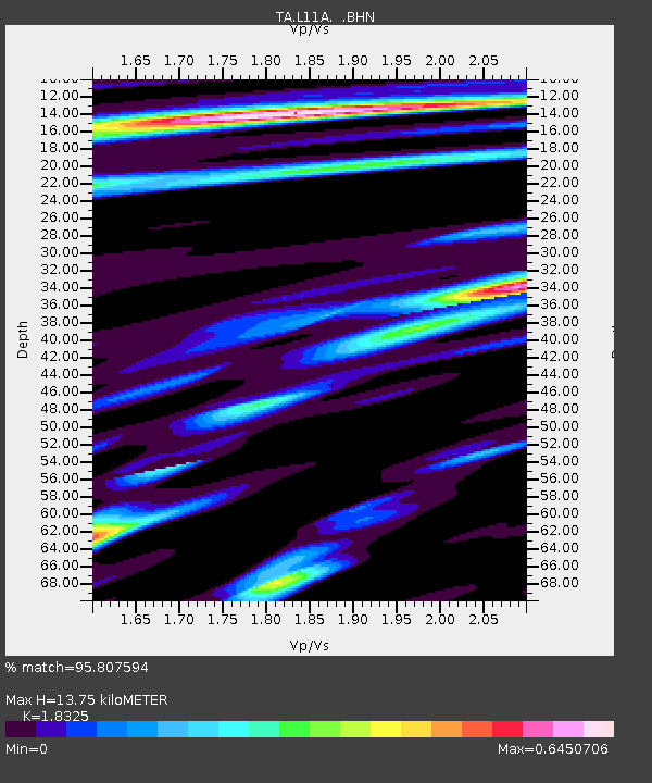
| Estimated Moho Depth: |
13.75 km |
| Estimated Crust Vp/Vs: |
1.83 |
| Assumed Crust Vp: |
6.291 km/s |
| Estimated Crust Vs: |
3.433 km/s |
| Estimated Crust Poisson's Ratio: |
0.29 |
|
| Radial Match: |
95.807594 % |
| Radial Bump: |
318 |
| Transverse Match: |
80.75658 % |
| Transverse Bump: |
400 |
| SOD ConfigId: |
2564 |
| Insert Time: |
2010-03-07 05:08:10.203 +0000 |
| GWidth: |
2.5 |
| Max Bumps: |
400 |
| Tol: |
0.001 |
|
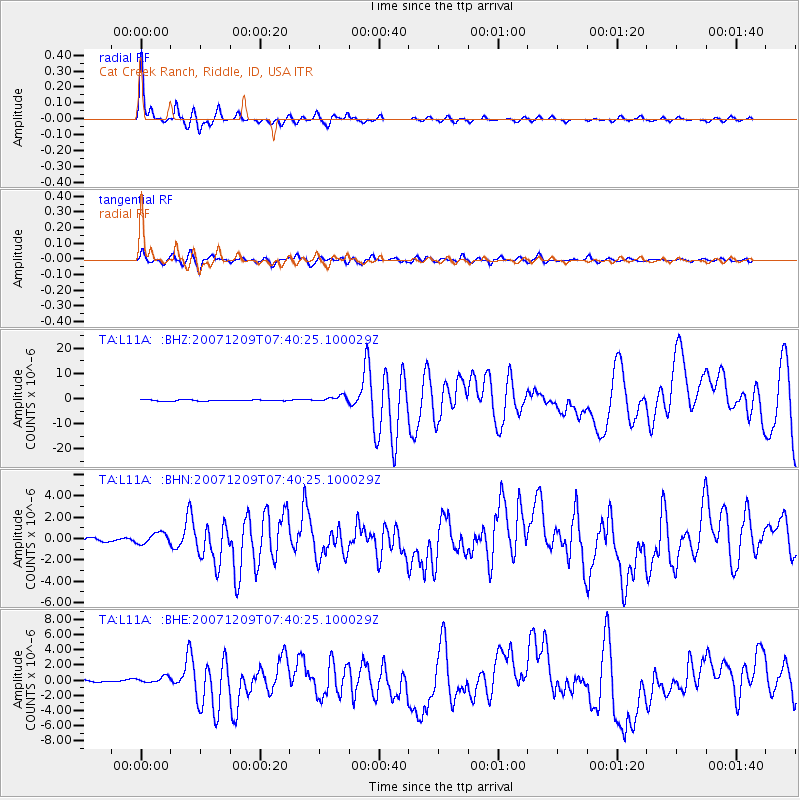
Signal To Noise
| Channel | StoN | STA | LTA |
| TA:L11A: :BHN:20071209T07:40:25.100029Z | 2.3325 | 5.464307E-7 | 2.3426828E-7 |
| TA:L11A: :BHE:20071209T07:40:25.100029Z | 3.292961 | 4.206535E-7 | 1.2774323E-7 |
| TA:L11A: :BHZ:20071209T07:40:25.100029Z | 4.835606 | 1.2526324E-6 | 2.590435E-7 |
| Arrivals |
| Ps | 1.9 SECOND |
| PpPs | 6.1 SECOND |
| PsPs/PpSs | 7.9 SECOND |


