You are here: Home > Network List > UU - University of Utah Regional Network Stations List
> Station CCUT Cedar City, UT, USA > Earthquake Result Viewer
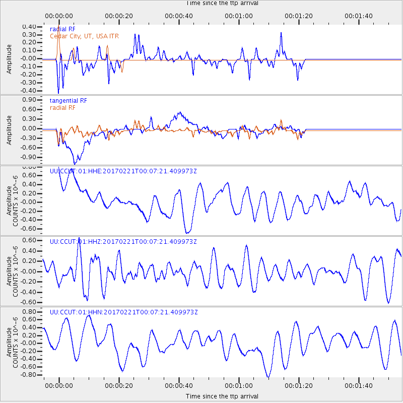
CCUT Cedar City, UT, USA - Earthquake Result Viewer
*The percent match for this event was below the threshold and hence no stack was calculated.
| Earthquake location: |
Fiji Islands Region |
| Earthquake latitude/longitude: |
-15.0/-176.4 |
| Earthquake time(UTC): |
2017/02/20 (051) 23:55:48 GMT |
| Earthquake Depth: |
6.0 km |
| Earthquake Magnitude: |
5.5 Mww |
| Earthquake Catalog/Contributor: |
NEIC PDE/us |
|
| Network: |
UU University of Utah Regional Network |
| Station: |
CCUT Cedar City, UT, USA |
| Lat/Lon: |
37.55 N/113.36 W |
| Elevation: |
2127 m |
|
| Distance: |
78.9 deg |
| Az: |
46.203 deg |
| Baz: |
241.367 deg |
| Ray Param: |
$rayparam |
*The percent match for this event was below the threshold and hence was not used in the summary stack. |
|
| Radial Match: |
76.35713 % |
| Radial Bump: |
400 |
| Transverse Match: |
29.650238 % |
| Transverse Bump: |
400 |
| SOD ConfigId: |
1992691 |
| Insert Time: |
2017-03-07 00:01:03.350 +0000 |
| GWidth: |
2.5 |
| Max Bumps: |
400 |
| Tol: |
0.001 |
|
Signal To Noise
| Channel | StoN | STA | LTA |
| UU:CCUT:01:HHZ:20170221T00:07:21.409973Z | 0.5979451 | 1.2602804E-7 | 2.107686E-7 |
| UU:CCUT:01:HHN:20170221T00:07:21.409973Z | 1.6822985 | 6.604663E-7 | 3.9259757E-7 |
| UU:CCUT:01:HHE:20170221T00:07:21.409973Z | 1.6373476 | 3.8769485E-7 | 2.3678226E-7 |
| Arrivals |
| Ps | |
| PpPs | |
| PsPs/PpSs | |


