You are here: Home > Network List > TA - USArray Transportable Network (new EarthScope stations) Stations List
> Station L11A Cat Creek Ranch, Riddle, ID, USA > Earthquake Result Viewer
L11A Cat Creek Ranch, Riddle, ID, USA - Earthquake Result Viewer
| Earthquake location: |
Volcano Islands, Japan Region |
| Earthquake latitude/longitude: |
22.0/142.7 |
| Earthquake time(UTC): |
2007/09/28 (271) 13:38:59 GMT |
| Earthquake Depth: |
276 km |
| Earthquake Magnitude: |
6.7 MB, 7.4 MW, 7.4 MW |
| Earthquake Catalog/Contributor: |
WHDF/NEIC |
|
| Network: |
TA USArray Transportable Network (new EarthScope stations) |
| Station: |
L11A Cat Creek Ranch, Riddle, ID, USA |
| Lat/Lon: |
42.17 N/115.75 W |
| Elevation: |
1511 m |
|
| Distance: |
83.7 deg |
| Az: |
47.117 deg |
| Baz: |
293.839 deg |
| Ray Param: |
0.045337398 |
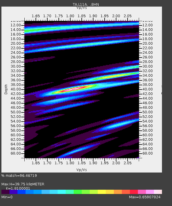
| Estimated Moho Depth: |
39.75 km |
| Estimated Crust Vp/Vs: |
1.81 |
| Assumed Crust Vp: |
6.291 km/s |
| Estimated Crust Vs: |
3.476 km/s |
| Estimated Crust Poisson's Ratio: |
0.28 |
|
| Radial Match: |
96.46719 % |
| Radial Bump: |
358 |
| Transverse Match: |
83.90634 % |
| Transverse Bump: |
400 |
| SOD ConfigId: |
2564 |
| Insert Time: |
2010-03-07 05:08:23.177 +0000 |
| GWidth: |
2.5 |
| Max Bumps: |
400 |
| Tol: |
0.001 |
|
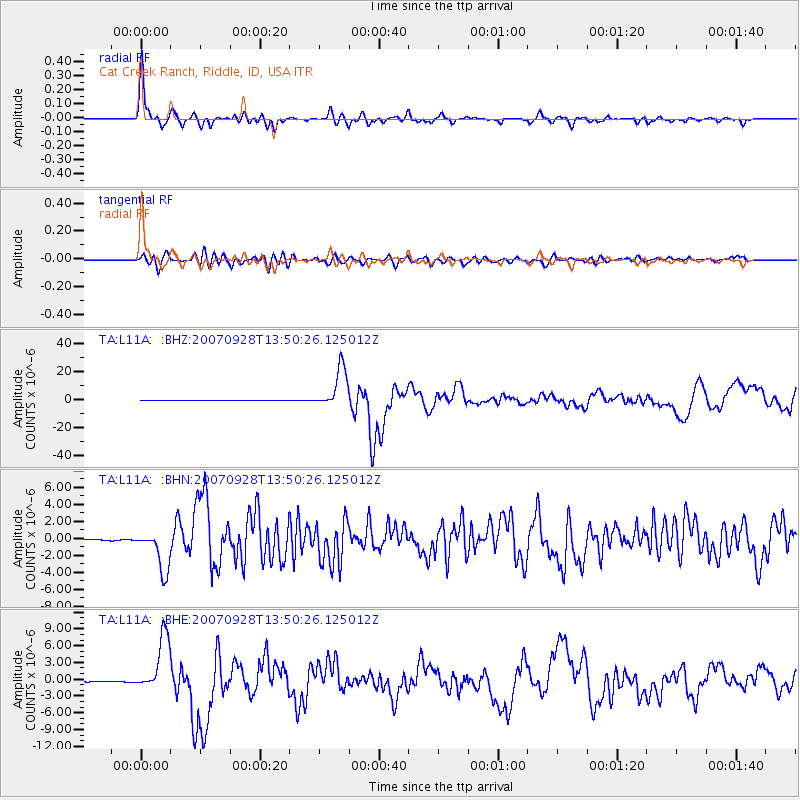
Signal To Noise
| Channel | StoN | STA | LTA |
| TA:L11A: :BHN:20070928T13:50:26.125012Z | 22.00762 | 2.4705569E-6 | 1.1225915E-7 |
| TA:L11A: :BHE:20070928T13:50:26.125012Z | 31.524939 | 5.0317412E-6 | 1.5961146E-7 |
| TA:L11A: :BHZ:20070928T13:50:26.125012Z | 103.43885 | 1.4587205E-5 | 1.410225E-7 |
| Arrivals |
| Ps | 5.2 SECOND |
| PpPs | 17 SECOND |
| PsPs/PpSs | 23 SECOND |


