You are here: Home > Network List > TA - USArray Transportable Network (new EarthScope stations) Stations List
> Station L11A Cat Creek Ranch, Riddle, ID, USA > Earthquake Result Viewer
L11A Cat Creek Ranch, Riddle, ID, USA - Earthquake Result Viewer
| Earthquake location: |
Kuril Islands |
| Earthquake latitude/longitude: |
45.8/150.1 |
| Earthquake time(UTC): |
2007/09/03 (246) 16:14:53 GMT |
| Earthquake Depth: |
94 km |
| Earthquake Magnitude: |
6.3 MB, 6.2 MW, 6.2 ME |
| Earthquake Catalog/Contributor: |
WHDF/NEIC |
|
| Network: |
TA USArray Transportable Network (new EarthScope stations) |
| Station: |
L11A Cat Creek Ranch, Riddle, ID, USA |
| Lat/Lon: |
42.17 N/115.75 W |
| Elevation: |
1511 m |
|
| Distance: |
63.9 deg |
| Az: |
55.668 deg |
| Baz: |
309.053 deg |
| Ray Param: |
0.059034776 |
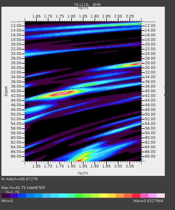
| Estimated Moho Depth: |
40.75 km |
| Estimated Crust Vp/Vs: |
1.76 |
| Assumed Crust Vp: |
6.291 km/s |
| Estimated Crust Vs: |
3.575 km/s |
| Estimated Crust Poisson's Ratio: |
0.26 |
|
| Radial Match: |
88.97279 % |
| Radial Bump: |
368 |
| Transverse Match: |
79.423416 % |
| Transverse Bump: |
374 |
| SOD ConfigId: |
2564 |
| Insert Time: |
2010-03-07 05:08:26.620 +0000 |
| GWidth: |
2.5 |
| Max Bumps: |
400 |
| Tol: |
0.001 |
|

Signal To Noise
| Channel | StoN | STA | LTA |
| TA:L11A: :BHN:20070903T16:24:45.525017Z | 10.388451 | 1.0833188E-6 | 1.0428108E-7 |
| TA:L11A: :BHE:20070903T16:24:45.525017Z | 11.284705 | 1.121592E-6 | 9.939046E-8 |
| TA:L11A: :BHZ:20070903T16:24:45.525017Z | 29.471527 | 3.3945275E-6 | 1.15179894E-7 |
| Arrivals |
| Ps | 5.1 SECOND |
| PpPs | 17 SECOND |
| PsPs/PpSs | 22 SECOND |


