You are here: Home > Network List > AG - Arkansas Seismic Network Stations List
> Station LCAR Lake Charles,AR > Earthquake Result Viewer
LCAR Lake Charles,AR - Earthquake Result Viewer
| Earthquake location: |
Southern Bolivia |
| Earthquake latitude/longitude: |
-19.3/-63.9 |
| Earthquake time(UTC): |
2017/02/21 (052) 14:09:04 GMT |
| Earthquake Depth: |
598 km |
| Earthquake Magnitude: |
6.5 Mww |
| Earthquake Catalog/Contributor: |
NEIC PDE/us |
|
| Network: |
AG Arkansas Seismic Network |
| Station: |
LCAR Lake Charles,AR |
| Lat/Lon: |
36.07 N/91.15 W |
| Elevation: |
103 m |
|
| Distance: |
60.8 deg |
| Az: |
334.847 deg |
| Baz: |
150.294 deg |
| Ray Param: |
0.058921512 |
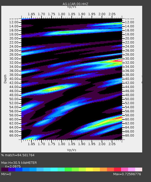
| Estimated Moho Depth: |
30.5 km |
| Estimated Crust Vp/Vs: |
2.10 |
| Assumed Crust Vp: |
6.53 km/s |
| Estimated Crust Vs: |
3.113 km/s |
| Estimated Crust Poisson's Ratio: |
0.35 |
|
| Radial Match: |
94.581764 % |
| Radial Bump: |
380 |
| Transverse Match: |
86.37373 % |
| Transverse Bump: |
381 |
| SOD ConfigId: |
1992691 |
| Insert Time: |
2017-03-07 14:10:23.932 +0000 |
| GWidth: |
2.5 |
| Max Bumps: |
400 |
| Tol: |
0.001 |
|
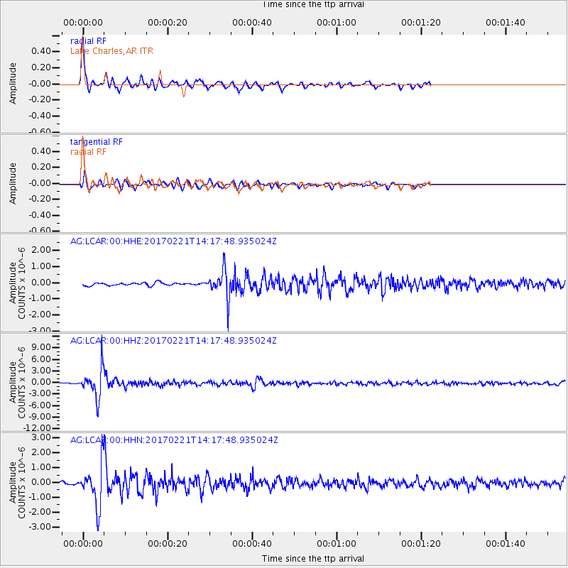
Signal To Noise
| Channel | StoN | STA | LTA |
| AG:LCAR:00:HHZ:20170221T14:17:48.935024Z | 25.606108 | 3.8441635E-6 | 1.5012682E-7 |
| AG:LCAR:00:HHN:20170221T14:17:48.935024Z | 14.435992 | 1.4198215E-6 | 9.8352885E-8 |
| AG:LCAR:00:HHE:20170221T14:17:48.935024Z | 9.659588 | 8.3799233E-7 | 8.6752394E-8 |
| Arrivals |
| Ps | 5.3 SECOND |
| PpPs | 14 SECOND |
| PsPs/PpSs | 19 SECOND |


