You are here: Home > Network List > TA - USArray Transportable Network (new EarthScope stations) Stations List
> Station L11A Cat Creek Ranch, Riddle, ID, USA > Earthquake Result Viewer
L11A Cat Creek Ranch, Riddle, ID, USA - Earthquake Result Viewer
| Earthquake location: |
South Of Mariana Islands |
| Earthquake latitude/longitude: |
12.5/143.2 |
| Earthquake time(UTC): |
2008/05/09 (130) 21:51:29 GMT |
| Earthquake Depth: |
76 km |
| Earthquake Magnitude: |
6.1 MB, 6.7 MW, 6.7 MW |
| Earthquake Catalog/Contributor: |
WHDF/NEIC |
|
| Network: |
TA USArray Transportable Network (new EarthScope stations) |
| Station: |
L11A Cat Creek Ranch, Riddle, ID, USA |
| Lat/Lon: |
42.17 N/115.75 W |
| Elevation: |
1511 m |
|
| Distance: |
89.7 deg |
| Az: |
46.854 deg |
| Baz: |
286.585 deg |
| Ray Param: |
0.041709863 |
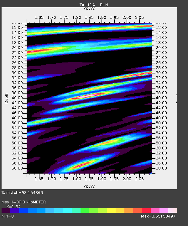
| Estimated Moho Depth: |
39.0 km |
| Estimated Crust Vp/Vs: |
1.84 |
| Assumed Crust Vp: |
6.291 km/s |
| Estimated Crust Vs: |
3.419 km/s |
| Estimated Crust Poisson's Ratio: |
0.29 |
|
| Radial Match: |
93.154366 % |
| Radial Bump: |
400 |
| Transverse Match: |
82.21069 % |
| Transverse Bump: |
400 |
| SOD ConfigId: |
2504 |
| Insert Time: |
2010-03-07 05:09:07.928 +0000 |
| GWidth: |
2.5 |
| Max Bumps: |
400 |
| Tol: |
0.001 |
|

Signal To Noise
| Channel | StoN | STA | LTA |
| TA:L11A: :BHN:20080509T22:03:48.349019Z | 9.757793 | 5.897943E-7 | 6.044341E-8 |
| TA:L11A: :BHE:20080509T22:03:48.349019Z | 2.0412428 | 1.0805155E-7 | 5.2934194E-8 |
| TA:L11A: :BHZ:20080509T22:03:48.349019Z | 5.186655 | 1.9508981E-7 | 3.7613802E-8 |
| Arrivals |
| Ps | 5.3 SECOND |
| PpPs | 17 SECOND |
| PsPs/PpSs | 23 SECOND |


