You are here: Home > Network List > CU - Caribbean Network (USGS) Stations List
> Station GRGR Grenville, Grenada > Earthquake Result Viewer
GRGR Grenville, Grenada - Earthquake Result Viewer
| Earthquake location: |
Southern Bolivia |
| Earthquake latitude/longitude: |
-19.3/-63.9 |
| Earthquake time(UTC): |
2017/02/21 (052) 14:09:04 GMT |
| Earthquake Depth: |
598 km |
| Earthquake Magnitude: |
6.5 Mww |
| Earthquake Catalog/Contributor: |
NEIC PDE/us |
|
| Network: |
CU Caribbean Network (USGS) |
| Station: |
GRGR Grenville, Grenada |
| Lat/Lon: |
12.13 N/61.65 W |
| Elevation: |
195 m |
|
| Distance: |
31.3 deg |
| Az: |
4.229 deg |
| Baz: |
184.085 deg |
| Ray Param: |
0.07634741 |
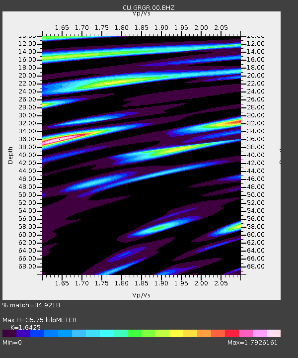
| Estimated Moho Depth: |
35.75 km |
| Estimated Crust Vp/Vs: |
1.64 |
| Assumed Crust Vp: |
5.738 km/s |
| Estimated Crust Vs: |
3.494 km/s |
| Estimated Crust Poisson's Ratio: |
0.21 |
|
| Radial Match: |
84.9218 % |
| Radial Bump: |
400 |
| Transverse Match: |
75.02375 % |
| Transverse Bump: |
400 |
| SOD ConfigId: |
1992691 |
| Insert Time: |
2017-03-07 14:11:18.813 +0000 |
| GWidth: |
2.5 |
| Max Bumps: |
400 |
| Tol: |
0.001 |
|

Signal To Noise
| Channel | StoN | STA | LTA |
| CU:GRGR:00:BHZ:20170221T14:14:06.848995Z | 38.734314 | 9.867542E-6 | 2.5474935E-7 |
| CU:GRGR:00:BH1:20170221T14:14:06.848995Z | 16.314646 | 5.706801E-6 | 3.4979618E-7 |
| CU:GRGR:00:BH2:20170221T14:14:06.848995Z | 9.584305 | 3.6066253E-6 | 3.7630537E-7 |
| Arrivals |
| Ps | 4.3 SECOND |
| PpPs | 15 SECOND |
| PsPs/PpSs | 20 SECOND |


