You are here: Home > Network List > IU - Global Seismograph Network (GSN - IRIS/USGS) Stations List
> Station PMG Port Moresby, New Guinea > Earthquake Result Viewer
PMG Port Moresby, New Guinea - Earthquake Result Viewer
*The percent match for this event was below the threshold and hence no stack was calculated.
| Earthquake location: |
Southern Sumatra, Indonesia |
| Earthquake latitude/longitude: |
-2.6/99.6 |
| Earthquake time(UTC): |
2019/10/21 (294) 23:49:04 GMT |
| Earthquake Depth: |
10 km |
| Earthquake Magnitude: |
5.2 Mww |
| Earthquake Catalog/Contributor: |
NEIC PDE/us |
|
| Network: |
IU Global Seismograph Network (GSN - IRIS/USGS) |
| Station: |
PMG Port Moresby, New Guinea |
| Lat/Lon: |
9.40 S/147.16 E |
| Elevation: |
90 m |
|
| Distance: |
47.7 deg |
| Az: |
100.252 deg |
| Baz: |
274.984 deg |
| Ray Param: |
$rayparam |
*The percent match for this event was below the threshold and hence was not used in the summary stack. |
|
| Radial Match: |
52.334183 % |
| Radial Bump: |
400 |
| Transverse Match: |
49.69603 % |
| Transverse Bump: |
400 |
| SOD ConfigId: |
19951751 |
| Insert Time: |
2019-11-04 23:54:38.574 +0000 |
| GWidth: |
2.5 |
| Max Bumps: |
400 |
| Tol: |
0.001 |
|
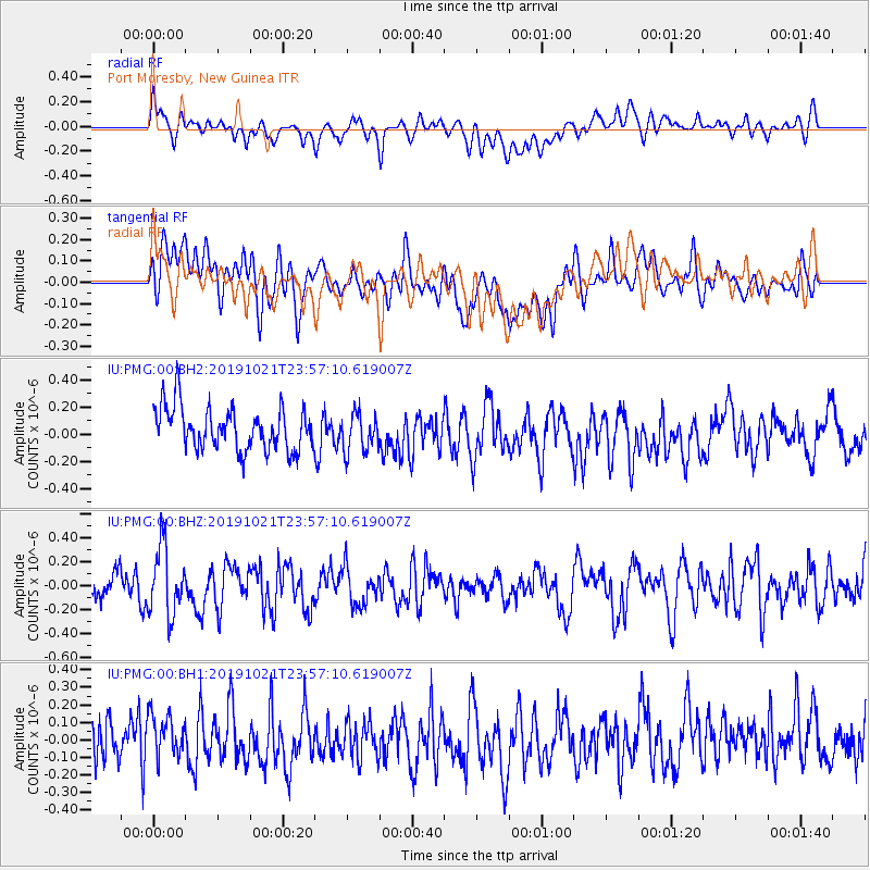
Signal To Noise
| Channel | StoN | STA | LTA |
| IU:PMG:00:BHZ:20191021T23:57:10.619007Z | 2.2915483 | 2.8316512E-7 | 1.2356934E-7 |
| IU:PMG:00:BH1:20191021T23:57:10.619007Z | 0.98555577 | 1.6341022E-7 | 1.6580515E-7 |
| IU:PMG:00:BH2:20191021T23:57:10.619007Z | 0.8864639 | 1.4111905E-7 | 1.5919322E-7 |
| Arrivals |
| Ps | |
| PpPs | |
| PsPs/PpSs | |


