You are here: Home > Network List > TA - USArray Transportable Network (new EarthScope stations) Stations List
> Station T16A Glen Canyon Dam (National Park Service), Page, AZ, > Earthquake Result Viewer
T16A Glen Canyon Dam (National Park Service), Page, AZ, - Earthquake Result Viewer
| Earthquake location: |
Andreanof Islands, Aleutian Is. |
| Earthquake latitude/longitude: |
51.4/-179.0 |
| Earthquake time(UTC): |
2007/12/21 (355) 07:24:34 GMT |
| Earthquake Depth: |
30 km |
| Earthquake Magnitude: |
6.1 MB, 6.2 MW, 6.3 ML |
| Earthquake Catalog/Contributor: |
WHDF/NEIC |
|
| Network: |
TA USArray Transportable Network (new EarthScope stations) |
| Station: |
T16A Glen Canyon Dam (National Park Service), Page, AZ, |
| Lat/Lon: |
36.98 N/111.51 W |
| Elevation: |
1177 m |
|
| Distance: |
48.8 deg |
| Az: |
79.539 deg |
| Baz: |
309.646 deg |
| Ray Param: |
0.069079876 |
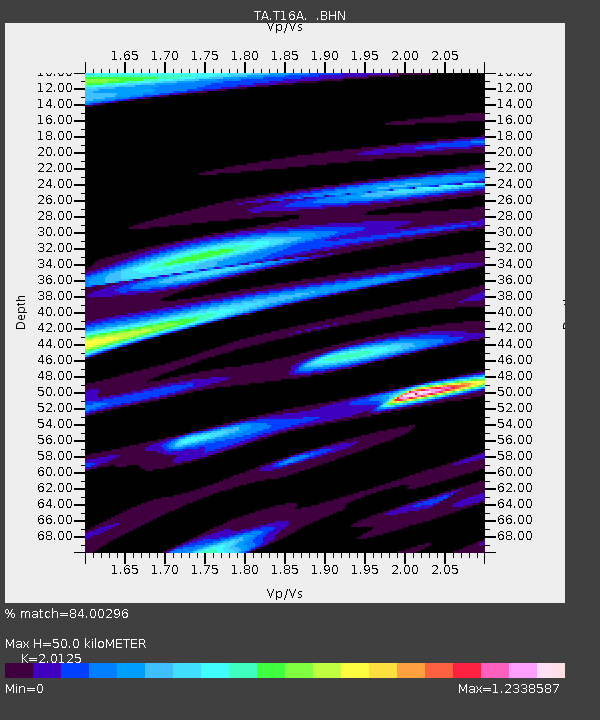
| Estimated Moho Depth: |
50.0 km |
| Estimated Crust Vp/Vs: |
2.01 |
| Assumed Crust Vp: |
6.247 km/s |
| Estimated Crust Vs: |
3.104 km/s |
| Estimated Crust Poisson's Ratio: |
0.34 |
|
| Radial Match: |
84.00296 % |
| Radial Bump: |
400 |
| Transverse Match: |
69.91446 % |
| Transverse Bump: |
400 |
| SOD ConfigId: |
2564 |
| Insert Time: |
2010-03-07 05:10:14.717 +0000 |
| GWidth: |
2.5 |
| Max Bumps: |
400 |
| Tol: |
0.001 |
|
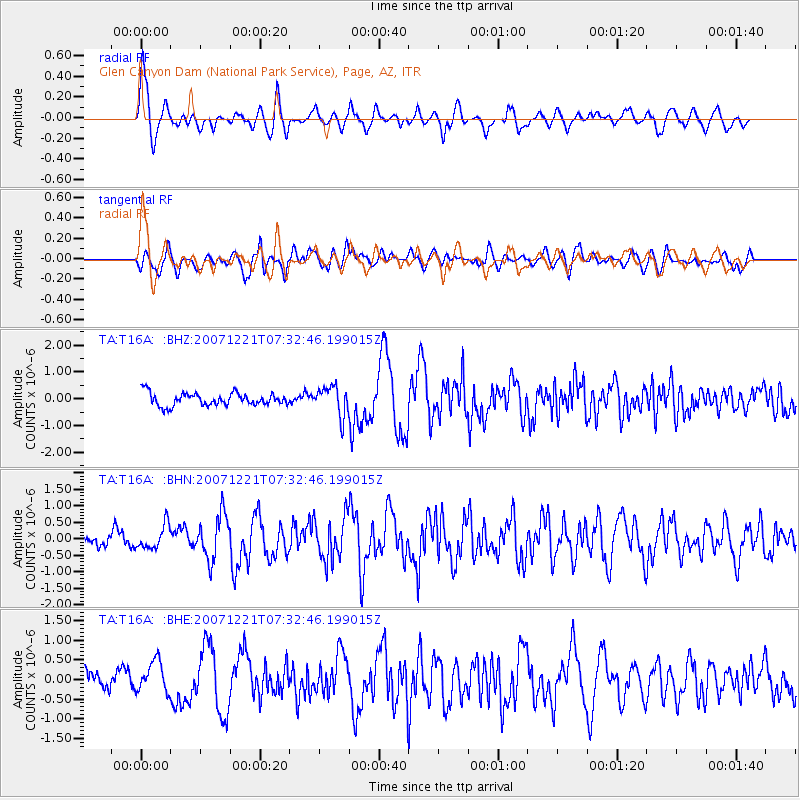
Signal To Noise
| Channel | StoN | STA | LTA |
| TA:T16A: :BHN:20071221T07:32:46.199015Z | 1.5789443 | 3.5946672E-7 | 2.2766271E-7 |
| TA:T16A: :BHE:20071221T07:32:46.199015Z | 1.7096896 | 4.0438874E-7 | 2.3652758E-7 |
| TA:T16A: :BHZ:20071221T07:32:46.199015Z | 2.2974863 | 5.451758E-7 | 2.3729231E-7 |
| Arrivals |
| Ps | 8.5 SECOND |
| PpPs | 23 SECOND |
| PsPs/PpSs | 31 SECOND |


