You are here: Home > Network List > TA - USArray Transportable Network (new EarthScope stations) Stations List
> Station T16A Glen Canyon Dam (National Park Service), Page, AZ, > Earthquake Result Viewer
T16A Glen Canyon Dam (National Park Service), Page, AZ, - Earthquake Result Viewer
| Earthquake location: |
Tonga Islands |
| Earthquake latitude/longitude: |
-17.5/-174.3 |
| Earthquake time(UTC): |
2007/08/26 (238) 12:37:31 GMT |
| Earthquake Depth: |
127 km |
| Earthquake Magnitude: |
5.9 MB, 6.1 MW |
| Earthquake Catalog/Contributor: |
WHDF/NEIC |
|
| Network: |
TA USArray Transportable Network (new EarthScope stations) |
| Station: |
T16A Glen Canyon Dam (National Park Service), Page, AZ, |
| Lat/Lon: |
36.98 N/111.51 W |
| Elevation: |
1177 m |
|
| Distance: |
80.2 deg |
| Az: |
46.299 deg |
| Baz: |
239.518 deg |
| Ray Param: |
0.04815396 |
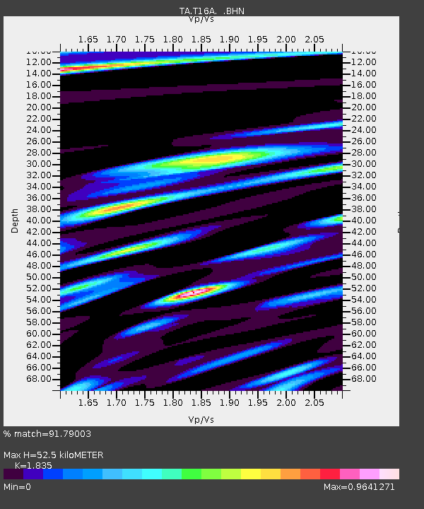
| Estimated Moho Depth: |
52.5 km |
| Estimated Crust Vp/Vs: |
1.84 |
| Assumed Crust Vp: |
6.247 km/s |
| Estimated Crust Vs: |
3.404 km/s |
| Estimated Crust Poisson's Ratio: |
0.29 |
|
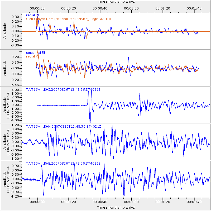
| Radial Match: |
91.79003 % |
| Radial Bump: |
400 |
| Transverse Match: |
81.61231 % |
| Transverse Bump: |
400 |
| SOD ConfigId: |
2564 |
| Insert Time: |
2010-03-07 05:10:30.724 +0000 |
| GWidth: |
2.5 |
| Max Bumps: |
400 |
| Tol: |
0.001 |
|
Signal To Noise
| Channel | StoN | STA | LTA |
| TA:T16A: :BHN:20070826T12:48:56.374021Z | 1.1696668 | 1.0239071E-7 | 8.753835E-8 |
| TA:T16A: :BHE:20070826T12:48:56.374021Z | 5.719462 | 4.7156078E-7 | 8.244846E-8 |
| TA:T16A: :BHZ:20070826T12:48:56.374021Z | 38.30922 | 2.0806629E-6 | 5.4312327E-8 |
| Arrivals |
| Ps | 7.2 SECOND |
| PpPs | 23 SECOND |
| PsPs/PpSs | 30 SECOND |


