You are here: Home > Network List > TA - USArray Transportable Network (new EarthScope stations) Stations List
> Station T16A Glen Canyon Dam (National Park Service), Page, AZ, > Earthquake Result Viewer
T16A Glen Canyon Dam (National Park Service), Page, AZ, - Earthquake Result Viewer
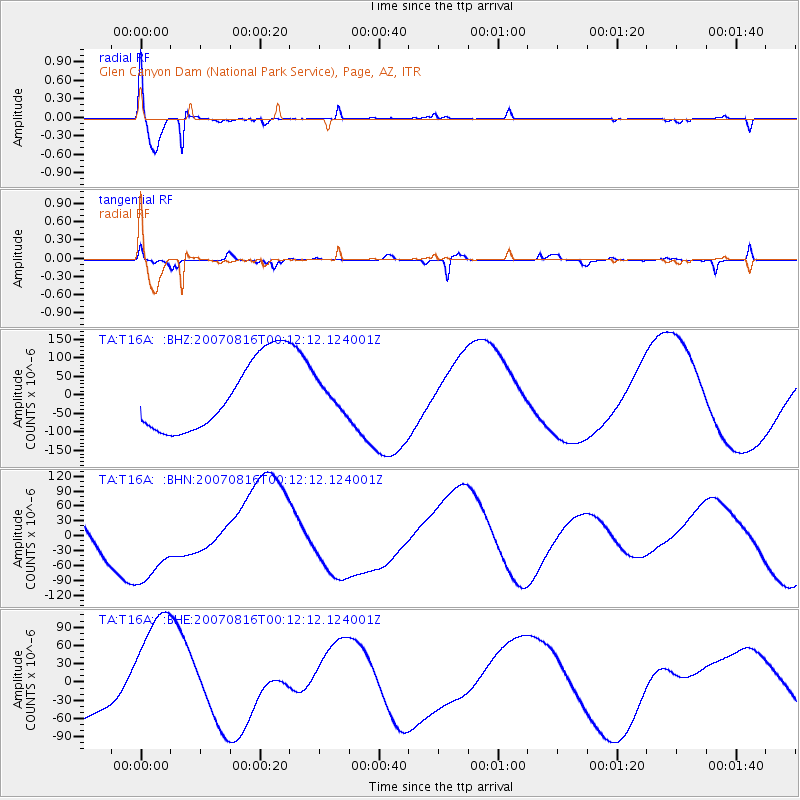
| Earthquake location: |
Near Coast Of Peru |
| Earthquake latitude/longitude: |
-13.3/-76.5 |
| Earthquake time(UTC): |
2007/08/16 (228) 00:02:41 GMT |
| Earthquake Depth: |
40 km |
| Earthquake Magnitude: |
5.6 MB |
| Earthquake Catalog/Contributor: |
WHDF/NEIC |
|
| Network: |
TA USArray Transportable Network (new EarthScope stations) |
| Station: |
T16A Glen Canyon Dam (National Park Service), Page, AZ, |
| Lat/Lon: |
36.98 N/111.51 W |
| Elevation: |
1177 m |
|
| Distance: |
59.9 deg |
| Az: |
327.907 deg |
| Baz: |
139.755 deg |
| Ray Param: |
0.06183234 |
| Estimated Moho Depth: |
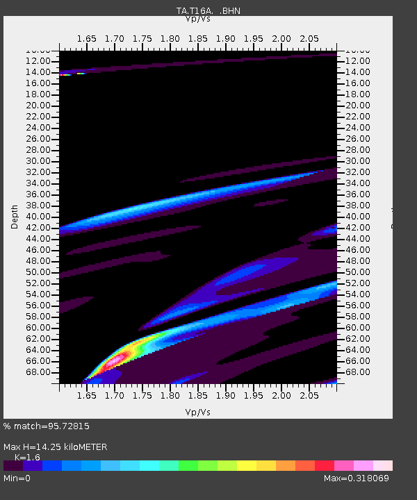
14.25 km |
| Estimated Crust Vp/Vs: |
1.60 |
| Assumed Crust Vp: |
6.247 km/s |
| Estimated Crust Vs: |
3.904 km/s |
| Estimated Crust Poisson's Ratio: |
0.18 |
|
| Radial Match: |
95.72815 % |
| Radial Bump: |
379 |
| Transverse Match: |
64.791405 % |
| Transverse Bump: |
354 |
| SOD ConfigId: |
2564 |
| Insert Time: |
2010-03-07 05:10:37.940 +0000 |
| GWidth: |
2.5 |
| Max Bumps: |
400 |
| Tol: |
0.001 |
|
Signal To Noise
| Channel | StoN | STA | LTA |
| TA:T16A: :BHN:20070816T00:12:12.124001Z | 1.6101363 | 9.616661E-5 | 5.972576E-5 |
| TA:T16A: :BHE:20070816T00:12:12.124001Z | 3.8681662 | 1.1316495E-4 | 2.9255452E-5 |
| TA:T16A: :BHZ:20070816T00:12:12.124001Z | 0.3670657 | 3.5561035E-5 | 9.6879216E-5 |
| Arrivals |
| Ps | 1.4 SECOND |
| PpPs | 5.6 SECOND |
| PsPs/PpSs | 7.1 SECOND |


