You are here: Home > Network List > TA - USArray Transportable Network (new EarthScope stations) Stations List
> Station T16A Glen Canyon Dam (National Park Service), Page, AZ, > Earthquake Result Viewer
T16A Glen Canyon Dam (National Park Service), Page, AZ, - Earthquake Result Viewer
| Earthquake location: |
South Of Panama |
| Earthquake latitude/longitude: |
5.0/-82.7 |
| Earthquake time(UTC): |
2008/06/17 (169) 17:42:09 GMT |
| Earthquake Depth: |
10 km |
| Earthquake Magnitude: |
5.6 MB, 5.3 MS, 5.9 MW, 5.9 MW |
| Earthquake Catalog/Contributor: |
WHDF/NEIC |
|
| Network: |
TA USArray Transportable Network (new EarthScope stations) |
| Station: |
T16A Glen Canyon Dam (National Park Service), Page, AZ, |
| Lat/Lon: |
36.98 N/111.51 W |
| Elevation: |
1177 m |
|
| Distance: |
41.4 deg |
| Az: |
324.208 deg |
| Baz: |
133.312 deg |
| Ray Param: |
0.073844336 |
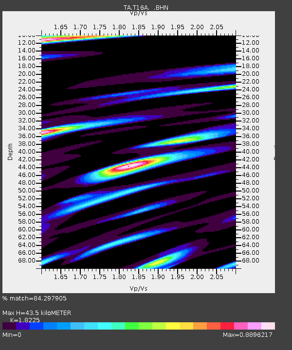
| Estimated Moho Depth: |
43.5 km |
| Estimated Crust Vp/Vs: |
1.82 |
| Assumed Crust Vp: |
6.247 km/s |
| Estimated Crust Vs: |
3.427 km/s |
| Estimated Crust Poisson's Ratio: |
0.28 |
|
| Radial Match: |
84.297905 % |
| Radial Bump: |
400 |
| Transverse Match: |
78.33556 % |
| Transverse Bump: |
400 |
| SOD ConfigId: |
2504 |
| Insert Time: |
2010-03-07 05:11:05.542 +0000 |
| GWidth: |
2.5 |
| Max Bumps: |
400 |
| Tol: |
0.001 |
|
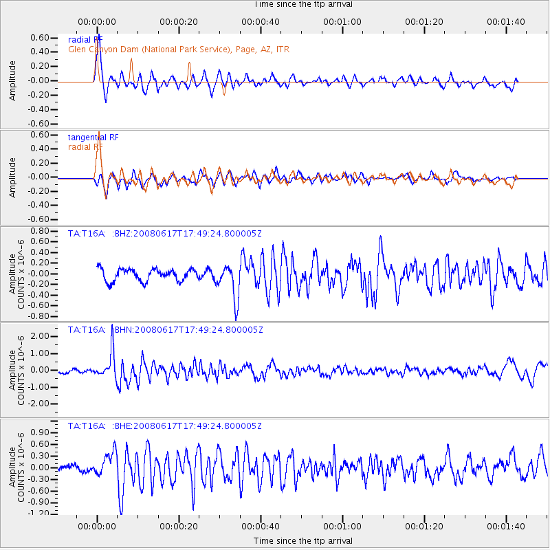
Signal To Noise
| Channel | StoN | STA | LTA |
| TA:T16A: :BHN:20080617T17:49:24.800005Z | 9.700462 | 8.2441665E-7 | 8.498736E-8 |
| TA:T16A: :BHE:20080617T17:49:24.800005Z | 3.040682 | 3.0350006E-7 | 9.981316E-8 |
| TA:T16A: :BHZ:20080617T17:49:24.800005Z | 2.9492223 | 3.3023403E-7 | 1.1197326E-7 |
| Arrivals |
| Ps | 6.1 SECOND |
| PpPs | 18 SECOND |
| PsPs/PpSs | 25 SECOND |


