You are here: Home > Network List > GS - US Geological Survey Networks Stations List
> Station KAN13 Rinehart Farm > Earthquake Result Viewer
KAN13 Rinehart Farm - Earthquake Result Viewer
*The percent match for this event was below the threshold and hence no stack was calculated.
| Earthquake location: |
Southern Bolivia |
| Earthquake latitude/longitude: |
-19.3/-63.9 |
| Earthquake time(UTC): |
2017/02/21 (052) 14:09:04 GMT |
| Earthquake Depth: |
598 km |
| Earthquake Magnitude: |
6.5 Mww |
| Earthquake Catalog/Contributor: |
NEIC PDE/us |
|
| Network: |
GS US Geological Survey Networks |
| Station: |
KAN13 Rinehart Farm |
| Lat/Lon: |
37.01 N/97.48 W |
| Elevation: |
340 m |
|
| Distance: |
64.3 deg |
| Az: |
330.582 deg |
| Baz: |
144.576 deg |
| Ray Param: |
$rayparam |
*The percent match for this event was below the threshold and hence was not used in the summary stack. |
|
| Radial Match: |
57.512104 % |
| Radial Bump: |
400 |
| Transverse Match: |
39.25727 % |
| Transverse Bump: |
400 |
| SOD ConfigId: |
1992691 |
| Insert Time: |
2017-03-07 14:12:42.406 +0000 |
| GWidth: |
2.5 |
| Max Bumps: |
400 |
| Tol: |
0.001 |
|
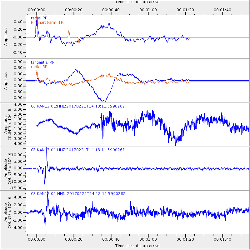
Signal To Noise
| Channel | StoN | STA | LTA |
| GS:KAN13:01:HHZ:20170221T14:18:11.599026Z | 25.747429 | 3.105158E-6 | 1.2060069E-7 |
| GS:KAN13:01:HHN:20170221T14:18:11.599026Z | 2.6760392 | 9.2258375E-7 | 3.4475718E-7 |
| GS:KAN13:01:HHE:20170221T14:18:11.599026Z | 0.76866925 | 6.9075696E-7 | 8.9864005E-7 |
| Arrivals |
| Ps | |
| PpPs | |
| PsPs/PpSs | |


