You are here: Home > Network List > TA - USArray Transportable Network (new EarthScope stations) Stations List
> Station T16A Glen Canyon Dam (National Park Service), Page, AZ, > Earthquake Result Viewer
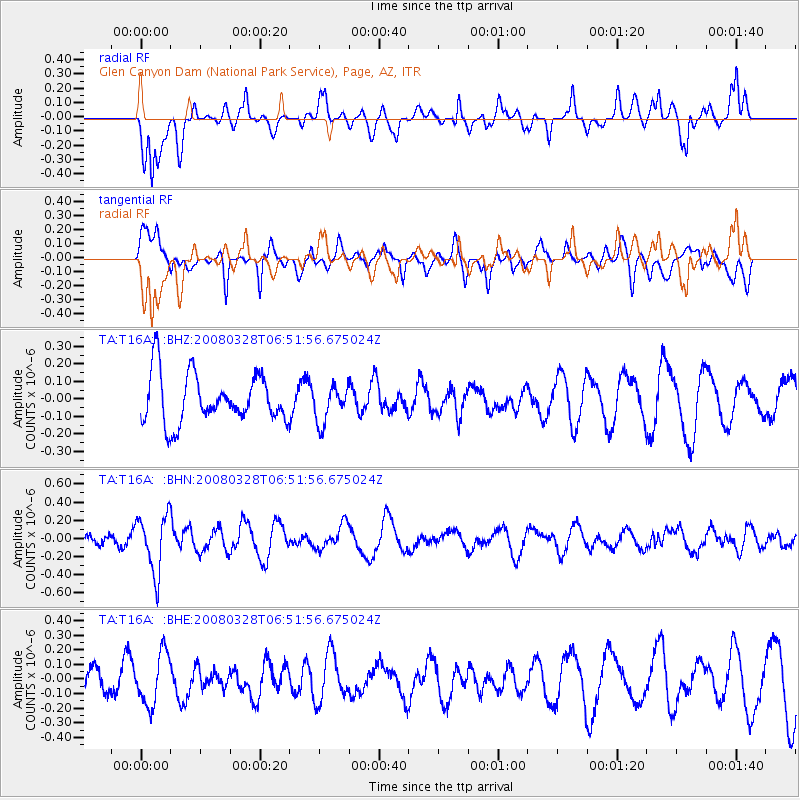
T16A Glen Canyon Dam (National Park Service), Page, AZ, - Earthquake Result Viewer
*The percent match for this event was below the threshold and hence no stack was calculated.
| Earthquake location: |
South Of Kermadec Islands |
| Earthquake latitude/longitude: |
-32.9/179.4 |
| Earthquake time(UTC): |
2008/03/28 (088) 06:39:47 GMT |
| Earthquake Depth: |
365 km |
| Earthquake Magnitude: |
5.6 MW, 5.3 MB, 5.5 MW |
| Earthquake Catalog/Contributor: |
WHDF/NEIC |
|
| Network: |
TA USArray Transportable Network (new EarthScope stations) |
| Station: |
T16A Glen Canyon Dam (National Park Service), Page, AZ, |
| Lat/Lon: |
36.98 N/111.51 W |
| Elevation: |
1177 m |
|
| Distance: |
94.8 deg |
| Az: |
48.664 deg |
| Baz: |
232.094 deg |
| Ray Param: |
$rayparam |
*The percent match for this event was below the threshold and hence was not used in the summary stack. |
|
| Radial Match: |
65.03994 % |
| Radial Bump: |
400 |
| Transverse Match: |
63.69517 % |
| Transverse Bump: |
400 |
| SOD ConfigId: |
2504 |
| Insert Time: |
2010-03-07 05:11:22.586 +0000 |
| GWidth: |
2.5 |
| Max Bumps: |
400 |
| Tol: |
0.001 |
|
Signal To Noise
| Channel | StoN | STA | LTA |
| TA:T16A: :BHN:20080328T06:51:56.675024Z | 3.4433105 | 3.1627505E-7 | 9.185202E-8 |
| TA:T16A: :BHE:20080328T06:51:56.675024Z | 1.7640232 | 1.7627974E-7 | 9.993051E-8 |
| TA:T16A: :BHZ:20080328T06:51:56.675024Z | 0.7439685 | 1.0313922E-7 | 1.3863387E-7 |
| Arrivals |
| Ps | |
| PpPs | |
| PsPs/PpSs | |


