You are here: Home > Network List > TA - USArray Transportable Network (new EarthScope stations) Stations List
> Station T16A Glen Canyon Dam (National Park Service), Page, AZ, > Earthquake Result Viewer
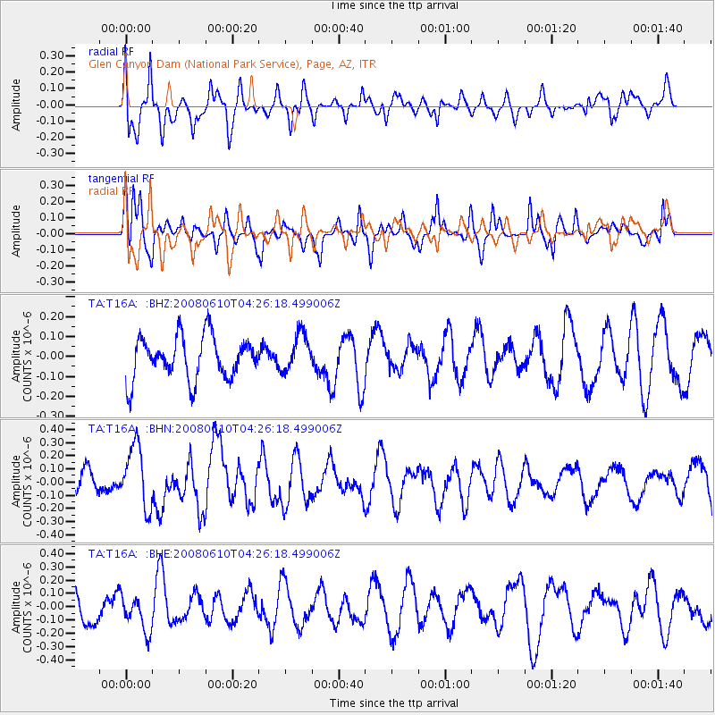
T16A Glen Canyon Dam (National Park Service), Page, AZ, - Earthquake Result Viewer
*The percent match for this event was below the threshold and hence no stack was calculated.
| Earthquake location: |
Vanuatu Islands |
| Earthquake latitude/longitude: |
-18.1/167.9 |
| Earthquake time(UTC): |
2008/06/10 (162) 04:13:37 GMT |
| Earthquake Depth: |
35 km |
| Earthquake Magnitude: |
5.7 MS, 5.3 MB, 5.9 MW, 5.8 MW |
| Earthquake Catalog/Contributor: |
WHDF/NEIC |
|
| Network: |
TA USArray Transportable Network (new EarthScope stations) |
| Station: |
T16A Glen Canyon Dam (National Park Service), Page, AZ, |
| Lat/Lon: |
36.98 N/111.51 W |
| Elevation: |
1177 m |
|
| Distance: |
93.5 deg |
| Az: |
52.324 deg |
| Baz: |
250.075 deg |
| Ray Param: |
$rayparam |
*The percent match for this event was below the threshold and hence was not used in the summary stack. |
|
| Radial Match: |
54.888985 % |
| Radial Bump: |
400 |
| Transverse Match: |
68.14876 % |
| Transverse Bump: |
390 |
| SOD ConfigId: |
2504 |
| Insert Time: |
2010-03-07 05:11:30.846 +0000 |
| GWidth: |
2.5 |
| Max Bumps: |
400 |
| Tol: |
0.001 |
|
Signal To Noise
| Channel | StoN | STA | LTA |
| TA:T16A: :BHN:20080610T04:26:18.499006Z | 2.7068067 | 2.3825363E-7 | 8.802019E-8 |
| TA:T16A: :BHE:20080610T04:26:18.499006Z | 0.88826895 | 1.3140557E-7 | 1.4793444E-7 |
| TA:T16A: :BHZ:20080610T04:26:18.499006Z | 0.9020464 | 9.639766E-8 | 1.0686553E-7 |
| Arrivals |
| Ps | |
| PpPs | |
| PsPs/PpSs | |


