You are here: Home > Network List > US - United States National Seismic Network Stations List
> Station AMTX Amarillo, Texas, USA > Earthquake Result Viewer
AMTX Amarillo, Texas, USA - Earthquake Result Viewer
*The percent match for this event was below the threshold and hence no stack was calculated.
| Earthquake location: |
Tonga Islands |
| Earthquake latitude/longitude: |
-15.2/-173.0 |
| Earthquake time(UTC): |
2019/10/22 (295) 04:18:38 GMT |
| Earthquake Depth: |
10 km |
| Earthquake Magnitude: |
5.8 mb |
| Earthquake Catalog/Contributor: |
NEIC PDE/us |
|
| Network: |
US United States National Seismic Network |
| Station: |
AMTX Amarillo, Texas, USA |
| Lat/Lon: |
34.53 N/101.41 W |
| Elevation: |
1010 m |
|
| Distance: |
84.0 deg |
| Az: |
51.986 deg |
| Baz: |
247.121 deg |
| Ray Param: |
$rayparam |
*The percent match for this event was below the threshold and hence was not used in the summary stack. |
|
| Radial Match: |
70.50507 % |
| Radial Bump: |
400 |
| Transverse Match: |
46.789593 % |
| Transverse Bump: |
400 |
| SOD ConfigId: |
19951751 |
| Insert Time: |
2019-11-05 04:35:35.696 +0000 |
| GWidth: |
2.5 |
| Max Bumps: |
400 |
| Tol: |
0.001 |
|
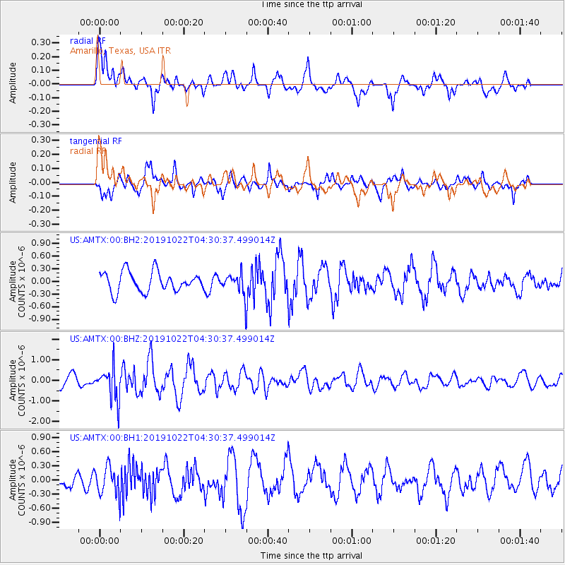
Signal To Noise
| Channel | StoN | STA | LTA |
| US:AMTX:00:BHZ:20191022T04:30:37.499014Z | 3.1093302 | 8.0657657E-7 | 2.5940525E-7 |
| US:AMTX:00:BH1:20191022T04:30:37.499014Z | 1.9270337 | 3.085775E-7 | 1.6013084E-7 |
| US:AMTX:00:BH2:20191022T04:30:37.499014Z | 1.4096519 | 3.2857338E-7 | 2.3308831E-7 |
| Arrivals |
| Ps | |
| PpPs | |
| PsPs/PpSs | |


