You are here: Home > Network List > US - United States National Seismic Network Stations List
> Station LAO LASA Array, Montana, USA > Earthquake Result Viewer
LAO LASA Array, Montana, USA - Earthquake Result Viewer
*The percent match for this event was below the threshold and hence no stack was calculated.
| Earthquake location: |
Tonga Islands |
| Earthquake latitude/longitude: |
-15.2/-173.0 |
| Earthquake time(UTC): |
2019/10/22 (295) 04:18:38 GMT |
| Earthquake Depth: |
10 km |
| Earthquake Magnitude: |
5.8 mb |
| Earthquake Catalog/Contributor: |
NEIC PDE/us |
|
| Network: |
US United States National Seismic Network |
| Station: |
LAO LASA Array, Montana, USA |
| Lat/Lon: |
46.69 N/106.22 W |
| Elevation: |
902 m |
|
| Distance: |
85.8 deg |
| Az: |
39.385 deg |
| Baz: |
242.863 deg |
| Ray Param: |
$rayparam |
*The percent match for this event was below the threshold and hence was not used in the summary stack. |
|
| Radial Match: |
51.625187 % |
| Radial Bump: |
400 |
| Transverse Match: |
56.16583 % |
| Transverse Bump: |
400 |
| SOD ConfigId: |
19951751 |
| Insert Time: |
2019-11-05 04:35:42.434 +0000 |
| GWidth: |
2.5 |
| Max Bumps: |
400 |
| Tol: |
0.001 |
|
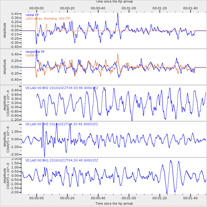
Signal To Noise
| Channel | StoN | STA | LTA |
| US:LAO:00:BHZ:20191022T04:30:46.900015Z | 2.0185165 | 6.442842E-7 | 3.19187E-7 |
| US:LAO:00:BH1:20191022T04:30:46.900015Z | 1.0582157 | 5.289122E-7 | 4.998151E-7 |
| US:LAO:00:BH2:20191022T04:30:46.900015Z | 1.3319054 | 5.9756525E-7 | 4.4865448E-7 |
| Arrivals |
| Ps | |
| PpPs | |
| PsPs/PpSs | |


