You are here: Home > Network List > GS - US Geological Survey Networks Stations List
> Station OK035 E0210 Rd and N2420 Rd, Alva, Oklahoma, USA > Earthquake Result Viewer
OK035 E0210 Rd and N2420 Rd, Alva, Oklahoma, USA - Earthquake Result Viewer
| Earthquake location: |
Southern Bolivia |
| Earthquake latitude/longitude: |
-19.3/-63.9 |
| Earthquake time(UTC): |
2017/02/21 (052) 14:09:04 GMT |
| Earthquake Depth: |
598 km |
| Earthquake Magnitude: |
6.5 Mww |
| Earthquake Catalog/Contributor: |
NEIC PDE/us |
|
| Network: |
GS US Geological Survey Networks |
| Station: |
OK035 E0210 Rd and N2420 Rd, Alva, Oklahoma, USA |
| Lat/Lon: |
36.71 N/98.71 W |
| Elevation: |
485 m |
|
| Distance: |
64.7 deg |
| Az: |
329.499 deg |
| Baz: |
143.374 deg |
| Ray Param: |
0.05652647 |
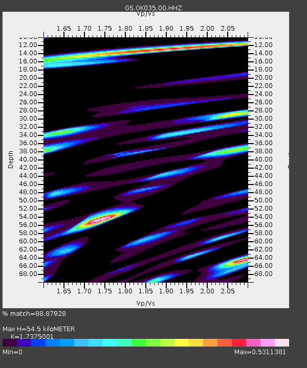
| Estimated Moho Depth: |
54.5 km |
| Estimated Crust Vp/Vs: |
1.74 |
| Assumed Crust Vp: |
6.426 km/s |
| Estimated Crust Vs: |
3.698 km/s |
| Estimated Crust Poisson's Ratio: |
0.25 |
|
| Radial Match: |
88.87928 % |
| Radial Bump: |
400 |
| Transverse Match: |
83.4204 % |
| Transverse Bump: |
400 |
| SOD ConfigId: |
1992691 |
| Insert Time: |
2017-03-07 14:13:01.165 +0000 |
| GWidth: |
2.5 |
| Max Bumps: |
400 |
| Tol: |
0.001 |
|

Signal To Noise
| Channel | StoN | STA | LTA |
| GS:OK035:00:HHZ:20170221T14:18:13.699001Z | 12.718065 | 2.7093924E-6 | 2.1303497E-7 |
| GS:OK035:00:HH1:20170221T14:18:13.699001Z | 1.9384099 | 7.8322836E-7 | 4.0405712E-7 |
| GS:OK035:00:HH2:20170221T14:18:13.699001Z | 1.5194606 | 6.827995E-7 | 4.4936968E-7 |
| Arrivals |
| Ps | 6.5 SECOND |
| PpPs | 22 SECOND |
| PsPs/PpSs | 29 SECOND |


