You are here: Home > Network List > TA - USArray Transportable Network (new EarthScope stations) Stations List
> Station T16A Glen Canyon Dam (National Park Service), Page, AZ, > Earthquake Result Viewer
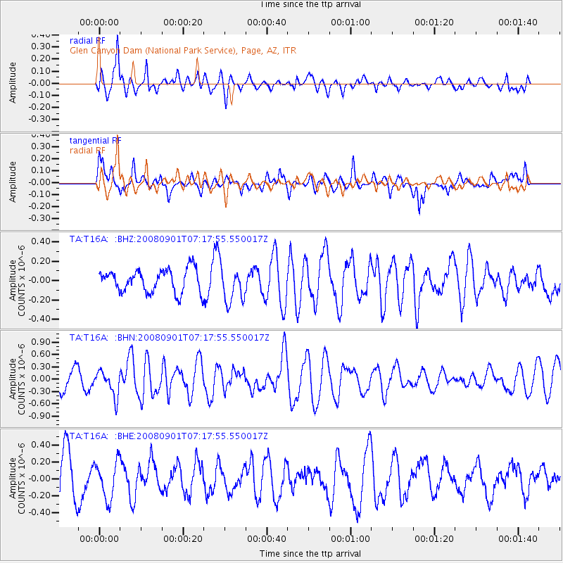
T16A Glen Canyon Dam (National Park Service), Page, AZ, - Earthquake Result Viewer
*The percent match for this event was below the threshold and hence no stack was calculated.
| Earthquake location: |
Fiji Islands Region |
| Earthquake latitude/longitude: |
-15.3/-176.4 |
| Earthquake time(UTC): |
2008/09/01 (245) 07:06:16 GMT |
| Earthquake Depth: |
10 km |
| Earthquake Magnitude: |
5.6 MS, 5.4 MB, 5.7 MW, 5.7 MW |
| Earthquake Catalog/Contributor: |
WHDF/NEIC |
|
| Network: |
TA USArray Transportable Network (new EarthScope stations) |
| Station: |
T16A Glen Canyon Dam (National Park Service), Page, AZ, |
| Lat/Lon: |
36.98 N/111.51 W |
| Elevation: |
1177 m |
|
| Distance: |
80.1 deg |
| Az: |
47.393 deg |
| Baz: |
242.52 deg |
| Ray Param: |
$rayparam |
*The percent match for this event was below the threshold and hence was not used in the summary stack. |
|
| Radial Match: |
59.656914 % |
| Radial Bump: |
400 |
| Transverse Match: |
71.224686 % |
| Transverse Bump: |
400 |
| SOD ConfigId: |
2504 |
| Insert Time: |
2010-03-07 05:11:42.474 +0000 |
| GWidth: |
2.5 |
| Max Bumps: |
400 |
| Tol: |
0.001 |
|
Signal To Noise
| Channel | StoN | STA | LTA |
| TA:T16A: :BHN:20080901T07:17:55.550017Z | 1.4493494 | 3.1817112E-7 | 2.1952685E-7 |
| TA:T16A: :BHE:20080901T07:17:55.550017Z | 0.7488979 | 2.2472933E-7 | 3.0008005E-7 |
| TA:T16A: :BHZ:20080901T07:17:55.550017Z | 1.5231602 | 1.7857178E-7 | 1.1723769E-7 |
| Arrivals |
| Ps | |
| PpPs | |
| PsPs/PpSs | |


