You are here: Home > Network List > TA - USArray Transportable Network (new EarthScope stations) Stations List
> Station L12A House Creek Ranch, Rogerson, ID, USA > Earthquake Result Viewer
L12A House Creek Ranch, Rogerson, ID, USA - Earthquake Result Viewer
| Earthquake location: |
Eastern Honshu, Japan |
| Earthquake latitude/longitude: |
39.8/141.5 |
| Earthquake time(UTC): |
2008/07/23 (205) 15:26:19 GMT |
| Earthquake Depth: |
108 km |
| Earthquake Magnitude: |
6.6 MB, 6.8 MW, 6.8 MW |
| Earthquake Catalog/Contributor: |
WHDF/NEIC |
|
| Network: |
TA USArray Transportable Network (new EarthScope stations) |
| Station: |
L12A House Creek Ranch, Rogerson, ID, USA |
| Lat/Lon: |
42.15 N/115.02 W |
| Elevation: |
1756 m |
|
| Distance: |
73.0 deg |
| Az: |
49.121 deg |
| Baz: |
308.442 deg |
| Ray Param: |
0.0530296 |
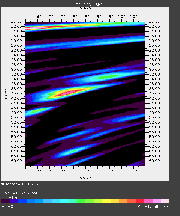
| Estimated Moho Depth: |
12.75 km |
| Estimated Crust Vp/Vs: |
1.60 |
| Assumed Crust Vp: |
6.291 km/s |
| Estimated Crust Vs: |
3.932 km/s |
| Estimated Crust Poisson's Ratio: |
0.18 |
|
| Radial Match: |
97.32714 % |
| Radial Bump: |
383 |
| Transverse Match: |
91.10652 % |
| Transverse Bump: |
400 |
| SOD ConfigId: |
2504 |
| Insert Time: |
2010-03-07 05:11:59.429 +0000 |
| GWidth: |
2.5 |
| Max Bumps: |
400 |
| Tol: |
0.001 |
|

Signal To Noise
| Channel | StoN | STA | LTA |
| TA:L12A: :BHN:20080723T15:37:07.025012Z | 41.22747 | 3.6811396E-6 | 8.928851E-8 |
| TA:L12A: :BHE:20080723T15:37:07.025012Z | 10.732705 | 1.1116109E-6 | 1.03572305E-7 |
| TA:L12A: :BHZ:20080723T15:37:07.025012Z | 12.771738 | 1.2668658E-6 | 9.9192896E-8 |
| Arrivals |
| Ps | 1.3 SECOND |
| PpPs | 5.1 SECOND |
| PsPs/PpSs | 6.3 SECOND |


