You are here: Home > Network List > TA - USArray Transportable Network (new EarthScope stations) Stations List
> Station L12A House Creek Ranch, Rogerson, ID, USA > Earthquake Result Viewer
L12A House Creek Ranch, Rogerson, ID, USA - Earthquake Result Viewer
| Earthquake location: |
Santa Cruz Islands |
| Earthquake latitude/longitude: |
-11.6/165.8 |
| Earthquake time(UTC): |
2007/09/02 (245) 01:05:18 GMT |
| Earthquake Depth: |
35 km |
| Earthquake Magnitude: |
5.9 MB, 7.3 MS, 7.2 MW, 6.9 ME |
| Earthquake Catalog/Contributor: |
WHDF/NEIC |
|
| Network: |
TA USArray Transportable Network (new EarthScope stations) |
| Station: |
L12A House Creek Ranch, Rogerson, ID, USA |
| Lat/Lon: |
42.15 N/115.02 W |
| Elevation: |
1756 m |
|
| Distance: |
89.9 deg |
| Az: |
46.933 deg |
| Baz: |
254.264 deg |
| Ray Param: |
0.04171084 |
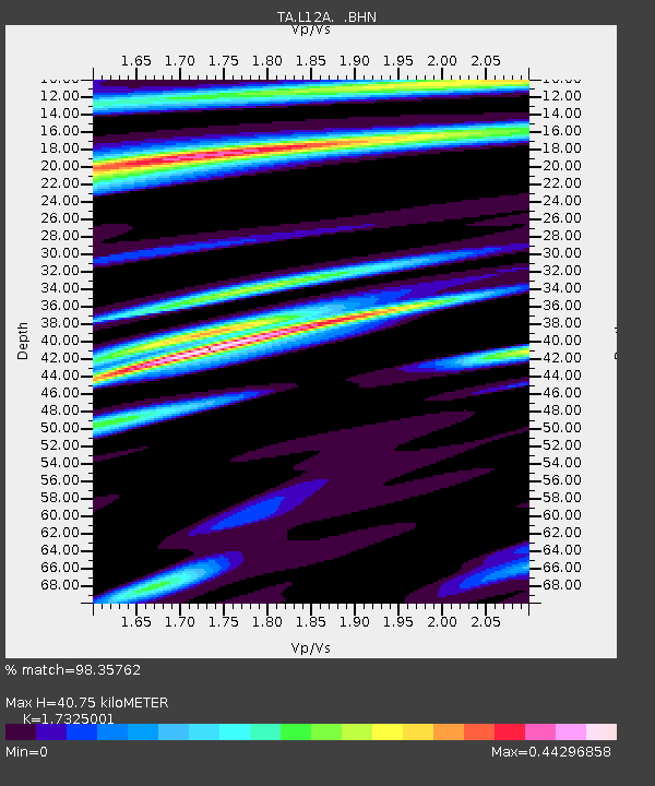
| Estimated Moho Depth: |
40.75 km |
| Estimated Crust Vp/Vs: |
1.73 |
| Assumed Crust Vp: |
6.291 km/s |
| Estimated Crust Vs: |
3.631 km/s |
| Estimated Crust Poisson's Ratio: |
0.25 |
|
| Radial Match: |
98.35762 % |
| Radial Bump: |
290 |
| Transverse Match: |
87.397194 % |
| Transverse Bump: |
400 |
| SOD ConfigId: |
2564 |
| Insert Time: |
2010-03-07 05:12:20.458 +0000 |
| GWidth: |
2.5 |
| Max Bumps: |
400 |
| Tol: |
0.001 |
|

Signal To Noise
| Channel | StoN | STA | LTA |
| TA:L12A: :BHN:20070902T01:17:42.100012Z | 2.658711 | 1.9632671E-7 | 7.384282E-8 |
| TA:L12A: :BHE:20070902T01:17:42.100012Z | 7.027656 | 8.000138E-7 | 1.13837935E-7 |
| TA:L12A: :BHZ:20070902T01:17:42.100012Z | 28.547697 | 2.22832E-6 | 7.805603E-8 |
| Arrivals |
| Ps | 4.8 SECOND |
| PpPs | 17 SECOND |
| PsPs/PpSs | 22 SECOND |


