You are here: Home > Network List > G - GEOSCOPE Stations List
> Station MPG Montagne des Peres, French Guyana > Earthquake Result Viewer
MPG Montagne des Peres, French Guyana - Earthquake Result Viewer
| Earthquake location: |
North Of Ascension Island |
| Earthquake latitude/longitude: |
-1.1/-13.8 |
| Earthquake time(UTC): |
2019/10/23 (296) 16:08:14 GMT |
| Earthquake Depth: |
10 km |
| Earthquake Magnitude: |
6.3 mww |
| Earthquake Catalog/Contributor: |
NEIC PDE/us |
|
| Network: |
G GEOSCOPE |
| Station: |
MPG Montagne des Peres, French Guyana |
| Lat/Lon: |
5.11 N/52.64 W |
| Elevation: |
147 m |
|
| Distance: |
39.3 deg |
| Az: |
279.336 deg |
| Baz: |
97.914 deg |
| Ray Param: |
0.075090215 |
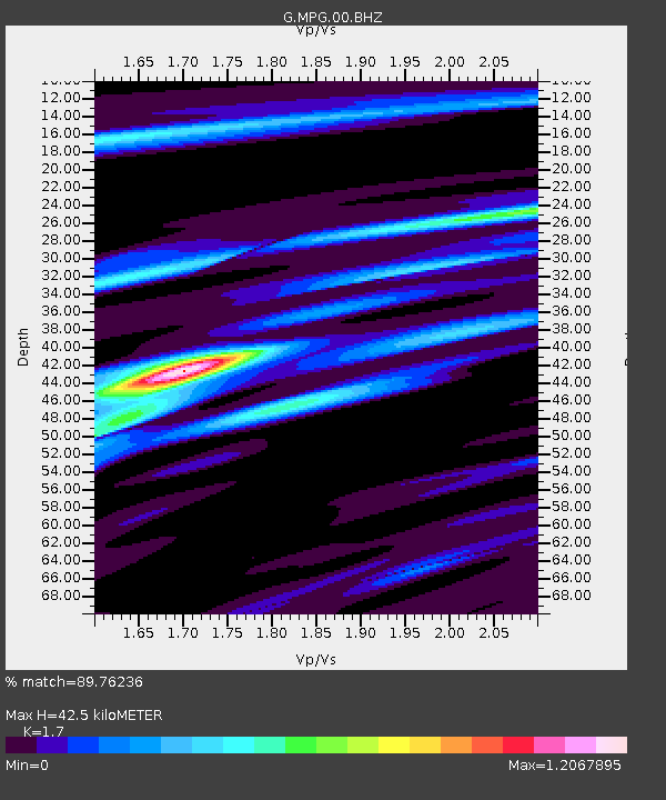
| Estimated Moho Depth: |
42.5 km |
| Estimated Crust Vp/Vs: |
1.70 |
| Assumed Crust Vp: |
6.472 km/s |
| Estimated Crust Vs: |
3.807 km/s |
| Estimated Crust Poisson's Ratio: |
0.24 |
|
| Radial Match: |
89.76236 % |
| Radial Bump: |
267 |
| Transverse Match: |
75.05749 % |
| Transverse Bump: |
400 |
| SOD ConfigId: |
19951751 |
| Insert Time: |
2019-11-06 16:16:02.562 +0000 |
| GWidth: |
2.5 |
| Max Bumps: |
400 |
| Tol: |
0.001 |
|

Signal To Noise
| Channel | StoN | STA | LTA |
| G:MPG:00:BHZ:20191023T16:15:12.200005Z | 7.5623183 | 6.613245E-7 | 8.7449976E-8 |
| G:MPG:00:BHN:20191023T16:15:12.200005Z | 1.5669577 | 1.1665491E-7 | 7.4446746E-8 |
| G:MPG:00:BHE:20191023T16:15:12.200005Z | 3.178153 | 3.9240246E-7 | 1.2346871E-7 |
| Arrivals |
| Ps | 5.0 SECOND |
| PpPs | 16 SECOND |
| PsPs/PpSs | 21 SECOND |


