You are here: Home > Network List > TA - USArray Transportable Network (new EarthScope stations) Stations List
> Station L12A House Creek Ranch, Rogerson, ID, USA > Earthquake Result Viewer
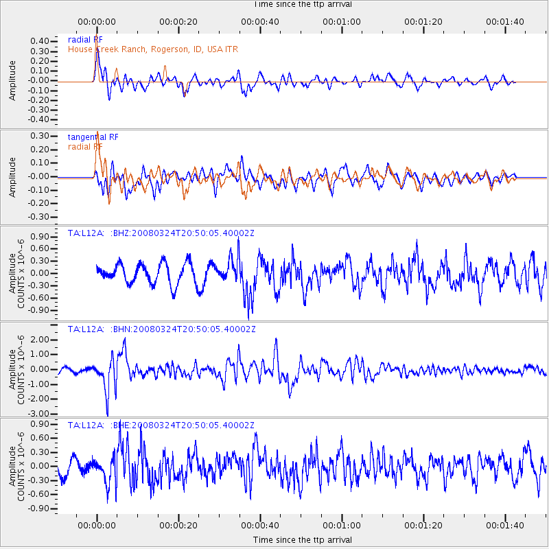
L12A House Creek Ranch, Rogerson, ID, USA - Earthquake Result Viewer
*The percent match for this event was below the threshold and hence no stack was calculated.
| Earthquake location: |
Chile-Bolivia Border Region |
| Earthquake latitude/longitude: |
-20.0/-69.0 |
| Earthquake time(UTC): |
2008/03/24 (084) 20:39:07 GMT |
| Earthquake Depth: |
120 km |
| Earthquake Magnitude: |
5.7 MB, 6.2 MW, 6.1 MW |
| Earthquake Catalog/Contributor: |
WHDF/NEIC |
|
| Network: |
TA USArray Transportable Network (new EarthScope stations) |
| Station: |
L12A House Creek Ranch, Rogerson, ID, USA |
| Lat/Lon: |
42.15 N/115.02 W |
| Elevation: |
1756 m |
|
| Distance: |
75.1 deg |
| Az: |
326.35 deg |
| Baz: |
135.531 deg |
| Ray Param: |
$rayparam |
*The percent match for this event was below the threshold and hence was not used in the summary stack. |
|
| Radial Match: |
73.450745 % |
| Radial Bump: |
400 |
| Transverse Match: |
64.997475 % |
| Transverse Bump: |
400 |
| SOD ConfigId: |
2504 |
| Insert Time: |
2010-03-07 05:13:23.160 +0000 |
| GWidth: |
2.5 |
| Max Bumps: |
400 |
| Tol: |
0.001 |
|
Signal To Noise
| Channel | StoN | STA | LTA |
| TA:L12A: :BHN:20080324T20:50:05.40002Z | 7.7954574 | 1.1031243E-6 | 1.4150861E-7 |
| TA:L12A: :BHE:20080324T20:50:05.40002Z | 1.5290686 | 2.834767E-7 | 1.8539176E-7 |
| TA:L12A: :BHZ:20080324T20:50:05.40002Z | 1.213629 | 2.9561448E-7 | 2.4357897E-7 |
| Arrivals |
| Ps | |
| PpPs | |
| PsPs/PpSs | |


