You are here: Home > Network List > UU - University of Utah Regional Network Stations List
> Station FORU South Mineral Mountains, UT, USA > Earthquake Result Viewer
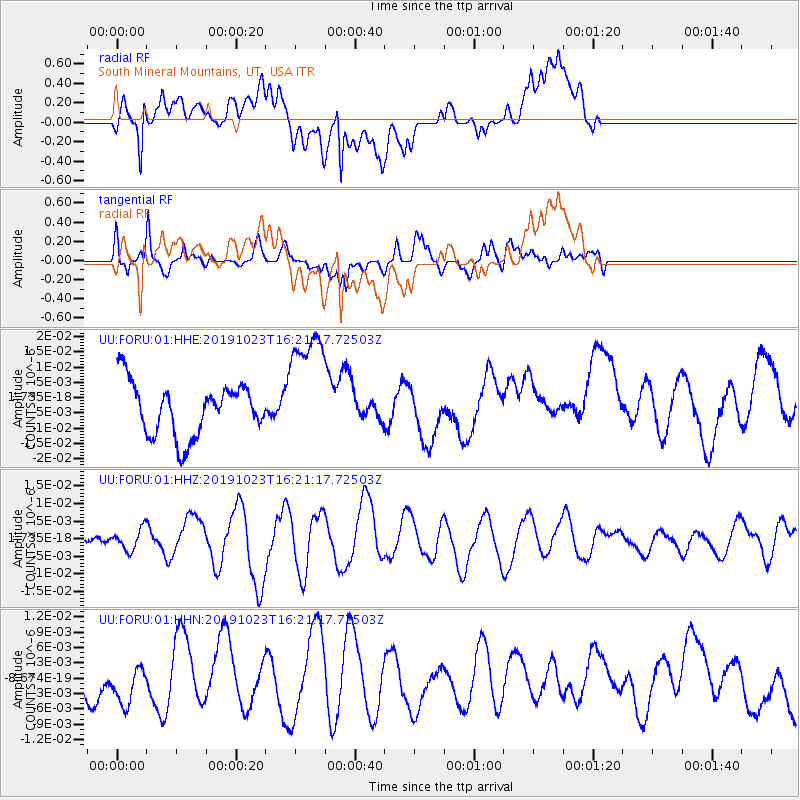
FORU South Mineral Mountains, UT, USA - Earthquake Result Viewer
*The percent match for this event was below the threshold and hence no stack was calculated.
| Earthquake location: |
North Of Ascension Island |
| Earthquake latitude/longitude: |
-1.1/-13.8 |
| Earthquake time(UTC): |
2019/10/23 (296) 16:08:14 GMT |
| Earthquake Depth: |
10 km |
| Earthquake Magnitude: |
6.3 mww |
| Earthquake Catalog/Contributor: |
NEIC PDE/us |
|
| Network: |
UU University of Utah Regional Network |
| Station: |
FORU South Mineral Mountains, UT, USA |
| Lat/Lon: |
38.46 N/112.86 W |
| Elevation: |
1840 m |
|
| Distance: |
97.7 deg |
| Az: |
308.513 deg |
| Baz: |
85.201 deg |
| Ray Param: |
$rayparam |
*The percent match for this event was below the threshold and hence was not used in the summary stack. |
|
| Radial Match: |
58.08643 % |
| Radial Bump: |
400 |
| Transverse Match: |
72.16158 % |
| Transverse Bump: |
400 |
| SOD ConfigId: |
19951751 |
| Insert Time: |
2019-11-06 16:22:58.617 +0000 |
| GWidth: |
2.5 |
| Max Bumps: |
400 |
| Tol: |
0.001 |
|
Signal To Noise
| Channel | StoN | STA | LTA |
| UU:FORU:01:HHZ:20191023T16:21:17.72503Z | 0.75117123 | 2.9922513E-9 | 3.983448E-9 |
| UU:FORU:01:HHN:20191023T16:21:17.72503Z | 1.2163796 | 4.2017123E-9 | 3.4542769E-9 |
| UU:FORU:01:HHE:20191023T16:21:17.72503Z | 2.3065226 | 1.9844604E-8 | 8.603689E-9 |
| Arrivals |
| Ps | |
| PpPs | |
| PsPs/PpSs | |


