You are here: Home > Network List > TA - USArray Transportable Network (new EarthScope stations) Stations List
> Station L12A House Creek Ranch, Rogerson, ID, USA > Earthquake Result Viewer
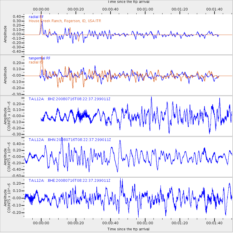
L12A House Creek Ranch, Rogerson, ID, USA - Earthquake Result Viewer
*The percent match for this event was below the threshold and hence no stack was calculated.
| Earthquake location: |
Samoa Islands Region |
| Earthquake latitude/longitude: |
-16.6/-173.0 |
| Earthquake time(UTC): |
2008/07/16 (198) 08:11:04 GMT |
| Earthquake Depth: |
10 km |
| Earthquake Magnitude: |
5.5 MB, 5.4 MS, 5.7 MW, 5.7 MW |
| Earthquake Catalog/Contributor: |
WHDF/NEIC |
|
| Network: |
TA USArray Transportable Network (new EarthScope stations) |
| Station: |
L12A House Creek Ranch, Rogerson, ID, USA |
| Lat/Lon: |
42.15 N/115.02 W |
| Elevation: |
1756 m |
|
| Distance: |
79.1 deg |
| Az: |
39.928 deg |
| Baz: |
235.846 deg |
| Ray Param: |
$rayparam |
*The percent match for this event was below the threshold and hence was not used in the summary stack. |
|
| Radial Match: |
69.01289 % |
| Radial Bump: |
400 |
| Transverse Match: |
67.04304 % |
| Transverse Bump: |
400 |
| SOD ConfigId: |
2504 |
| Insert Time: |
2010-03-07 05:13:43.967 +0000 |
| GWidth: |
2.5 |
| Max Bumps: |
400 |
| Tol: |
0.001 |
|
Signal To Noise
| Channel | StoN | STA | LTA |
| TA:L12A: :BHN:20080716T08:22:37.299011Z | 2.5440812 | 1.8786493E-7 | 7.384392E-8 |
| TA:L12A: :BHE:20080716T08:22:37.299011Z | 0.45081055 | 3.3138583E-8 | 7.3508886E-8 |
| TA:L12A: :BHZ:20080716T08:22:37.299011Z | 1.1177146 | 6.207405E-8 | 5.553658E-8 |
| Arrivals |
| Ps | |
| PpPs | |
| PsPs/PpSs | |


