You are here: Home > Network List > CN - Canadian National Seismograph Network Stations List
> Station INK INUVIK, NT > Earthquake Result Viewer
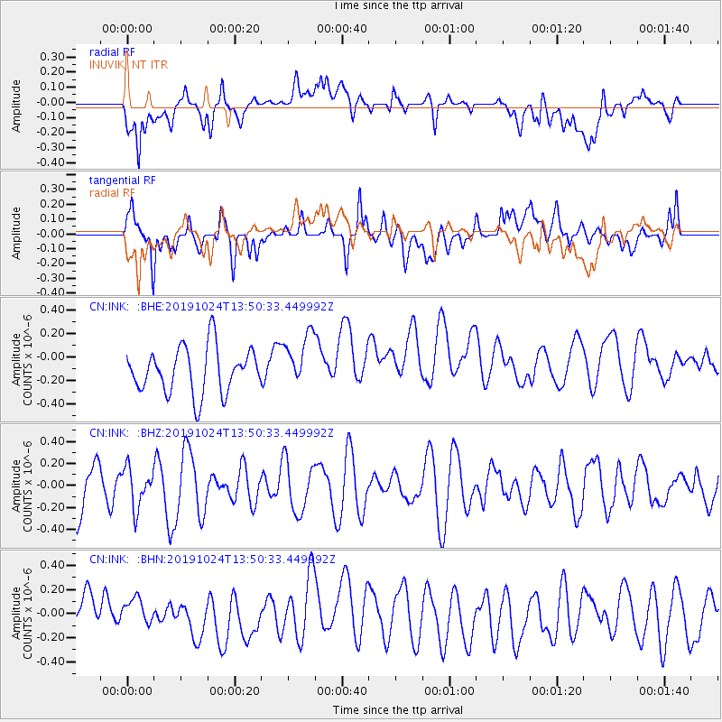
INK INUVIK, NT - Earthquake Result Viewer
*The percent match for this event was below the threshold and hence no stack was calculated.
| Earthquake location: |
Minahassa Peninsula, Sulawesi |
| Earthquake latitude/longitude: |
1.1/124.2 |
| Earthquake time(UTC): |
2019/10/24 (297) 13:38:17 GMT |
| Earthquake Depth: |
250 km |
| Earthquake Magnitude: |
5.6 Mww |
| Earthquake Catalog/Contributor: |
NEIC PDE/us |
|
| Network: |
CN Canadian National Seismograph Network |
| Station: |
INK INUVIK, NT |
| Lat/Lon: |
68.31 N/133.53 W |
| Elevation: |
44 m |
|
| Distance: |
93.5 deg |
| Az: |
21.343 deg |
| Baz: |
281.842 deg |
| Ray Param: |
$rayparam |
*The percent match for this event was below the threshold and hence was not used in the summary stack. |
|
| Radial Match: |
54.082745 % |
| Radial Bump: |
400 |
| Transverse Match: |
62.604343 % |
| Transverse Bump: |
400 |
| SOD ConfigId: |
19951751 |
| Insert Time: |
2019-11-07 13:44:18.113 +0000 |
| GWidth: |
2.5 |
| Max Bumps: |
400 |
| Tol: |
0.001 |
|
Signal To Noise
| Channel | StoN | STA | LTA |
| CN:INK: :BHZ:20191024T13:50:33.449992Z | 0.92789537 | 1.8139686E-7 | 1.954928E-7 |
| CN:INK: :BHN:20191024T13:50:33.449992Z | 0.75967175 | 1.2668426E-7 | 1.6676184E-7 |
| CN:INK: :BHE:20191024T13:50:33.449992Z | 1.183345 | 2.2878774E-7 | 1.9333986E-7 |
| Arrivals |
| Ps | |
| PpPs | |
| PsPs/PpSs | |


