You are here: Home > Network List > NM - Cooperative New Madrid Seismic Network Stations List
> Station PEBM Pemiscot Bayou,MO > Earthquake Result Viewer
PEBM Pemiscot Bayou,MO - Earthquake Result Viewer
| Earthquake location: |
Southern Bolivia |
| Earthquake latitude/longitude: |
-19.3/-63.9 |
| Earthquake time(UTC): |
2017/02/21 (052) 14:09:04 GMT |
| Earthquake Depth: |
598 km |
| Earthquake Magnitude: |
6.5 Mww |
| Earthquake Catalog/Contributor: |
NEIC PDE/us |
|
| Network: |
NM Cooperative New Madrid Seismic Network |
| Station: |
PEBM Pemiscot Bayou,MO |
| Lat/Lon: |
36.11 N/89.86 W |
| Elevation: |
76 m |
|
| Distance: |
60.3 deg |
| Az: |
335.921 deg |
| Baz: |
151.58 deg |
| Ray Param: |
0.05921215 |
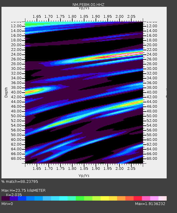
| Estimated Moho Depth: |
23.75 km |
| Estimated Crust Vp/Vs: |
2.04 |
| Assumed Crust Vp: |
6.444 km/s |
| Estimated Crust Vs: |
3.167 km/s |
| Estimated Crust Poisson's Ratio: |
0.34 |
|
| Radial Match: |
88.23795 % |
| Radial Bump: |
388 |
| Transverse Match: |
83.42388 % |
| Transverse Bump: |
400 |
| SOD ConfigId: |
1992691 |
| Insert Time: |
2017-03-07 14:15:06.485 +0000 |
| GWidth: |
2.5 |
| Max Bumps: |
400 |
| Tol: |
0.001 |
|

Signal To Noise
| Channel | StoN | STA | LTA |
| NM:PEBM:00:HHZ:20170221T14:17:45.860012Z | 54.79255 | 1.1719322E-5 | 2.1388531E-7 |
| NM:PEBM:00:HHN:20170221T14:17:45.860012Z | 4.48261 | 2.6735513E-6 | 5.9642736E-7 |
| NM:PEBM:00:HHE:20170221T14:17:45.860012Z | 7.3814263 | 2.6257476E-6 | 3.557236E-7 |
| Arrivals |
| Ps | 4.0 SECOND |
| PpPs | 11 SECOND |
| PsPs/PpSs | 15 SECOND |


