You are here: Home > Network List > NM - Cooperative New Madrid Seismic Network Stations List
> Station PENM Penman,Portageville,MO > Earthquake Result Viewer
PENM Penman,Portageville,MO - Earthquake Result Viewer
| Earthquake location: |
Southern Bolivia |
| Earthquake latitude/longitude: |
-19.3/-63.9 |
| Earthquake time(UTC): |
2017/02/21 (052) 14:09:04 GMT |
| Earthquake Depth: |
598 km |
| Earthquake Magnitude: |
6.5 Mww |
| Earthquake Catalog/Contributor: |
NEIC PDE/us |
|
| Network: |
NM Cooperative New Madrid Seismic Network |
| Station: |
PENM Penman,Portageville,MO |
| Lat/Lon: |
36.45 N/89.63 W |
| Elevation: |
85 m |
|
| Distance: |
60.5 deg |
| Az: |
336.296 deg |
| Baz: |
151.902 deg |
| Ray Param: |
0.05908284 |
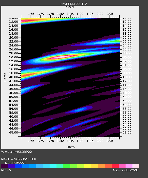
| Estimated Moho Depth: |
29.5 km |
| Estimated Crust Vp/Vs: |
1.81 |
| Assumed Crust Vp: |
6.444 km/s |
| Estimated Crust Vs: |
3.57 km/s |
| Estimated Crust Poisson's Ratio: |
0.28 |
|
| Radial Match: |
93.38922 % |
| Radial Bump: |
344 |
| Transverse Match: |
76.03274 % |
| Transverse Bump: |
344 |
| SOD ConfigId: |
1992691 |
| Insert Time: |
2017-03-07 14:15:07.852 +0000 |
| GWidth: |
2.5 |
| Max Bumps: |
400 |
| Tol: |
0.001 |
|

Signal To Noise
| Channel | StoN | STA | LTA |
| NM:PENM:00:HHZ:20170221T14:17:47.214993Z | 29.133295 | 1.0835632E-5 | 3.7193294E-7 |
| NM:PENM:00:HHN:20170221T14:17:47.214993Z | 4.7968388 | 2.551032E-6 | 5.318152E-7 |
| NM:PENM:00:HHE:20170221T14:17:47.214993Z | 2.1807885 | 1.8371625E-6 | 8.424304E-7 |
| Arrivals |
| Ps | 3.8 SECOND |
| PpPs | 12 SECOND |
| PsPs/PpSs | 16 SECOND |


