You are here: Home > Network List > TA - USArray Transportable Network (new EarthScope stations) Stations List
> Station Y14A Wickenburg, AZ, USA > Earthquake Result Viewer
Y14A Wickenburg, AZ, USA - Earthquake Result Viewer
| Earthquake location: |
Windward Islands |
| Earthquake latitude/longitude: |
15.0/-61.3 |
| Earthquake time(UTC): |
2007/11/29 (333) 19:00:19 GMT |
| Earthquake Depth: |
148 km |
| Earthquake Magnitude: |
6.9 MB, 7.4 MW, 7.4 MW |
| Earthquake Catalog/Contributor: |
WHDF/NEIC |
|
| Network: |
TA USArray Transportable Network (new EarthScope stations) |
| Station: |
Y14A Wickenburg, AZ, USA |
| Lat/Lon: |
33.94 N/113.00 W |
| Elevation: |
731 m |
|
| Distance: |
50.2 deg |
| Az: |
301.81 deg |
| Baz: |
98.92 deg |
| Ray Param: |
0.06770051 |
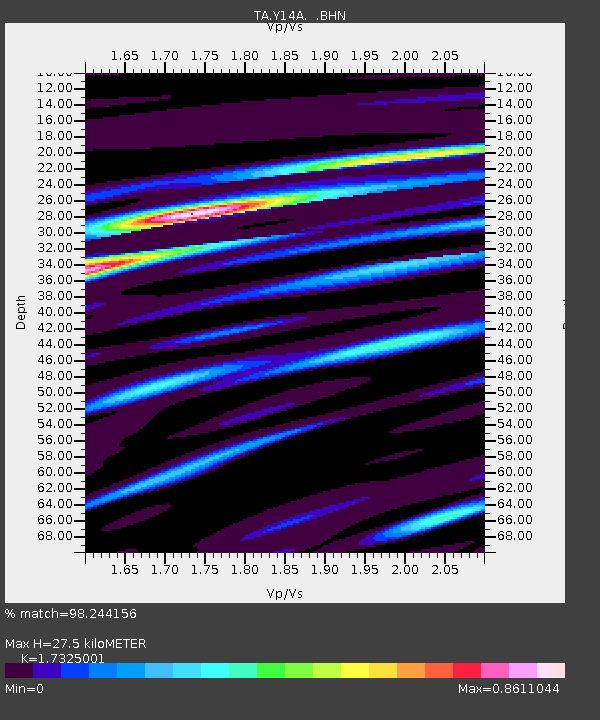
| Estimated Moho Depth: |
27.5 km |
| Estimated Crust Vp/Vs: |
1.73 |
| Assumed Crust Vp: |
6.264 km/s |
| Estimated Crust Vs: |
3.615 km/s |
| Estimated Crust Poisson's Ratio: |
0.25 |
|
| Radial Match: |
98.244156 % |
| Radial Bump: |
336 |
| Transverse Match: |
89.91731 % |
| Transverse Bump: |
400 |
| SOD ConfigId: |
2564 |
| Insert Time: |
2010-03-07 05:14:19.587 +0000 |
| GWidth: |
2.5 |
| Max Bumps: |
400 |
| Tol: |
0.001 |
|
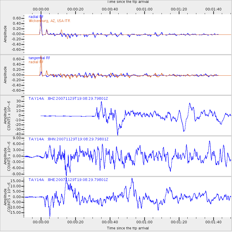
Signal To Noise
| Channel | StoN | STA | LTA |
| TA:Y14A: :BHN:20071129T19:08:29.79801Z | 9.0123825 | 1.3301327E-6 | 1.4758946E-7 |
| TA:Y14A: :BHE:20071129T19:08:29.79801Z | 16.516115 | 3.8344338E-6 | 2.321632E-7 |
| TA:Y14A: :BHZ:20071129T19:08:29.79801Z | 31.280699 | 8.251665E-6 | 2.6379416E-7 |
| Arrivals |
| Ps | 3.4 SECOND |
| PpPs | 11 SECOND |
| PsPs/PpSs | 15 SECOND |


