You are here: Home > Network List > TA - USArray Transportable Network (new EarthScope stations) Stations List
> Station Y14A Wickenburg, AZ, USA > Earthquake Result Viewer
Y14A Wickenburg, AZ, USA - Earthquake Result Viewer
| Earthquake location: |
Kuril Islands |
| Earthquake latitude/longitude: |
45.8/150.1 |
| Earthquake time(UTC): |
2007/09/03 (246) 16:14:53 GMT |
| Earthquake Depth: |
94 km |
| Earthquake Magnitude: |
6.3 MB, 6.2 MW, 6.2 ME |
| Earthquake Catalog/Contributor: |
WHDF/NEIC |
|
| Network: |
TA USArray Transportable Network (new EarthScope stations) |
| Station: |
Y14A Wickenburg, AZ, USA |
| Lat/Lon: |
33.94 N/113.00 W |
| Elevation: |
731 m |
|
| Distance: |
70.9 deg |
| Az: |
60.85 deg |
| Baz: |
312.742 deg |
| Ray Param: |
0.054451767 |
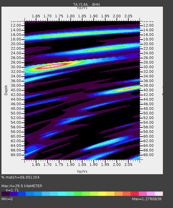
| Estimated Moho Depth: |
29.5 km |
| Estimated Crust Vp/Vs: |
1.71 |
| Assumed Crust Vp: |
6.264 km/s |
| Estimated Crust Vs: |
3.663 km/s |
| Estimated Crust Poisson's Ratio: |
0.24 |
|
| Radial Match: |
86.851204 % |
| Radial Bump: |
400 |
| Transverse Match: |
75.893715 % |
| Transverse Bump: |
400 |
| SOD ConfigId: |
2564 |
| Insert Time: |
2010-03-07 05:14:29.778 +0000 |
| GWidth: |
2.5 |
| Max Bumps: |
400 |
| Tol: |
0.001 |
|
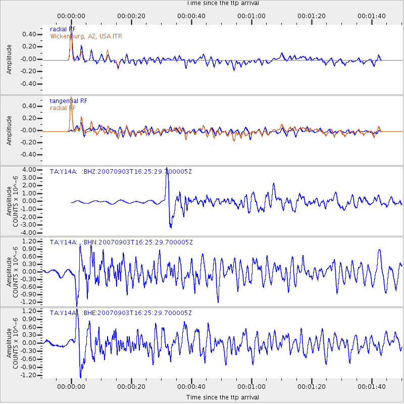
Signal To Noise
| Channel | StoN | STA | LTA |
| TA:Y14A: :BHN:20070903T16:25:29.700005Z | 6.2019563 | 5.581435E-7 | 8.999475E-8 |
| TA:Y14A: :BHE:20070903T16:25:29.700005Z | 8.099423 | 6.76193E-7 | 8.3486555E-8 |
| TA:Y14A: :BHZ:20070903T16:25:29.700005Z | 15.986773 | 2.0306015E-6 | 1.270176E-7 |
| Arrivals |
| Ps | 3.5 SECOND |
| PpPs | 12 SECOND |
| PsPs/PpSs | 16 SECOND |


