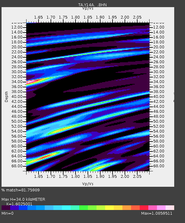
Y14A Wickenburg, AZ, USA - Earthquake Result Viewer
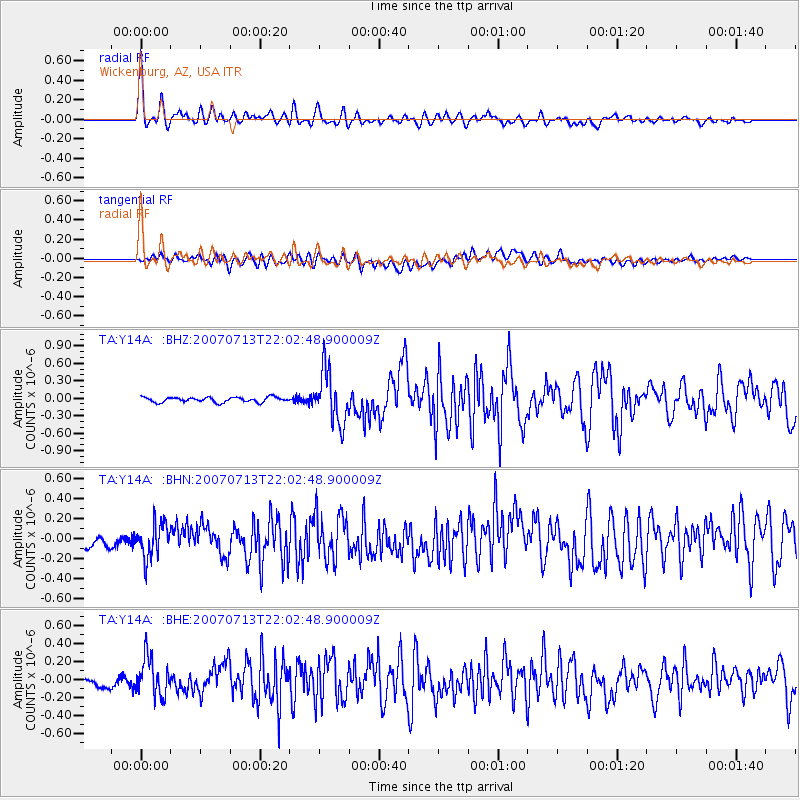
Earthquake location: Andreanof Islands, Aleutian Is.
Earthquake latitude/longitude: 51.8/-176.3
Earthquake time(UTC): 2007/07/13 (194) 21:54:43 GMT
Earthquake Depth: 35 km
Earthquake Magnitude: 5.7 MB, 5.6 MS, 6.0 MW, 5.9 MW
Earthquake Catalog/Contributor: WHDF/NEIC
Network: TA USArray Transportable Network (new EarthScope stations)
Station: Y14A Wickenburg, AZ, USA
Lat/Lon: 33.94 N/113.00 W
Elevation: 731 m
Distance: 48.1 deg
Az: 86.026 deg
Baz: 311.883 deg
Ray Param: 0.069504164
Estimated Moho Depth: 34.0 km
Estimated Crust Vp/Vs: 1.60
Assumed Crust Vp: 6.264 km/s
Estimated Crust Vs: 3.909 km/s
Estimated Crust Poisson's Ratio: 0.18
Radial Match: 81.75989 %
Radial Bump: 400
Transverse Match: 69.00985 %
Transverse Bump: 400
SOD ConfigId: 2564
Insert Time: 2010-03-07 05:14:52.564 +0000
GWidth: 2.5
Max Bumps: 400
Tol: 0.001

Signal To Noise

ChannelStoNSTALTA
TA:Y14A: :BHN:20070713T22:02:48.900009Z2.1970111.7638091E-78.0282206E-8
TA:Y14A: :BHE:20070713T22:02:48.900009Z3.05563472.1942714E-77.181066E-8
TA:Y14A: :BHZ:20070713T22:02:48.900009Z10.6005244.5216467E-74.2654936E-8
Arrivals
Ps3.5 SECOND
PpPs13 SECOND
PsPs/PpSs17 SECOND