You are here: Home > Network List > TA - USArray Transportable Network (new EarthScope stations) Stations List
> Station Y14A Wickenburg, AZ, USA > Earthquake Result Viewer
Y14A Wickenburg, AZ, USA - Earthquake Result Viewer
| Earthquake location: |
Peru-Brazil Border Region |
| Earthquake latitude/longitude: |
-7.9/-74.4 |
| Earthquake time(UTC): |
2007/07/12 (193) 05:23:49 GMT |
| Earthquake Depth: |
152 km |
| Earthquake Magnitude: |
5.9 MB, 6.1 MW, 6.0 MW |
| Earthquake Catalog/Contributor: |
WHDF/NEIC |
|
| Network: |
TA USArray Transportable Network (new EarthScope stations) |
| Station: |
Y14A Wickenburg, AZ, USA |
| Lat/Lon: |
33.94 N/113.00 W |
| Elevation: |
731 m |
|
| Distance: |
55.4 deg |
| Az: |
320.941 deg |
| Baz: |
131.343 deg |
| Ray Param: |
0.064292654 |
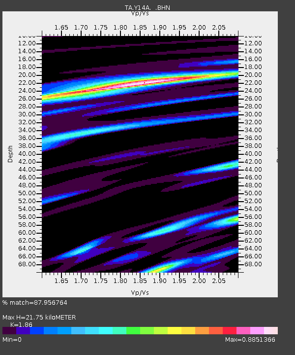
| Estimated Moho Depth: |
21.75 km |
| Estimated Crust Vp/Vs: |
1.86 |
| Assumed Crust Vp: |
6.264 km/s |
| Estimated Crust Vs: |
3.368 km/s |
| Estimated Crust Poisson's Ratio: |
0.30 |
|
| Radial Match: |
87.956764 % |
| Radial Bump: |
275 |
| Transverse Match: |
66.375946 % |
| Transverse Bump: |
400 |
| SOD ConfigId: |
2564 |
| Insert Time: |
2010-03-07 05:14:55.928 +0000 |
| GWidth: |
2.5 |
| Max Bumps: |
400 |
| Tol: |
0.001 |
|
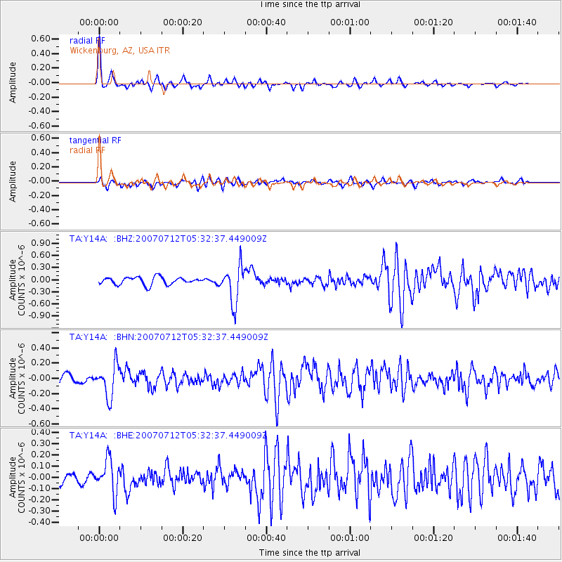
Signal To Noise
| Channel | StoN | STA | LTA |
| TA:Y14A: :BHN:20070712T05:32:37.449009Z | 4.586345 | 2.1871868E-7 | 4.7689102E-8 |
| TA:Y14A: :BHE:20070712T05:32:37.449009Z | 2.2531927 | 1.5489648E-7 | 6.874534E-8 |
| TA:Y14A: :BHZ:20070712T05:32:37.449009Z | 5.159897 | 4.6859756E-7 | 9.08153E-8 |
| Arrivals |
| Ps | 3.1 SECOND |
| PpPs | 9.5 SECOND |
| PsPs/PpSs | 13 SECOND |


