You are here: Home > Network List > TA - USArray Transportable Network (new EarthScope stations) Stations List
> Station Y14A Wickenburg, AZ, USA > Earthquake Result Viewer
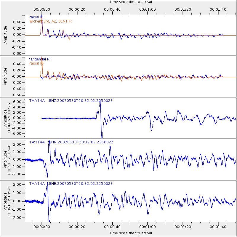
Y14A Wickenburg, AZ, USA - Earthquake Result Viewer

| Earthquake location: |
Kamchatka Peninsula, Russia |
| Earthquake latitude/longitude: |
52.1/157.3 |
| Earthquake time(UTC): |
2007/05/30 (150) 20:22:12 GMT |
| Earthquake Depth: |
116 km |
| Earthquake Magnitude: |
6.4 MB, 6.4 MW, 6.4 MW |
| Earthquake Catalog/Contributor: |
WHDF/NEIC |
|
| Network: |
TA USArray Transportable Network (new EarthScope stations) |
| Station: |
Y14A Wickenburg, AZ, USA |
| Lat/Lon: |
33.94 N/113.00 W |
| Elevation: |
731 m |
|
| Distance: |
63.9 deg |
| Az: |
67.809 deg |
| Baz: |
316.65 deg |
| Ray Param: |
0.058964733 |
| Estimated Moho Depth: |
21.75 km |
| Estimated Crust Vp/Vs: |
1.97 |
| Assumed Crust Vp: |
6.264 km/s |
| Estimated Crust Vs: |
3.175 km/s |
| Estimated Crust Poisson's Ratio: |
0.33 |
|
| Radial Match: |
93.81742 % |
| Radial Bump: |
400 |
| Transverse Match: |
88.40828 % |
| Transverse Bump: |
400 |
| SOD ConfigId: |
2564 |
| Insert Time: |
2010-03-07 05:15:02.020 +0000 |
| GWidth: |
2.5 |
| Max Bumps: |
400 |
| Tol: |
0.001 |
|
Signal To Noise
| Channel | StoN | STA | LTA |
| TA:Y14A: :BHN:20070530T20:32:02.225002Z | 9.211751 | 1.2415281E-6 | 1.3477657E-7 |
| TA:Y14A: :BHE:20070530T20:32:02.225002Z | 13.280011 | 1.2733701E-6 | 9.588623E-8 |
| TA:Y14A: :BHZ:20070530T20:32:02.225002Z | 43.551605 | 3.7293003E-6 | 8.562946E-8 |
| Arrivals |
| Ps | 3.5 SECOND |
| PpPs | 10.0 SECOND |
| PsPs/PpSs | 13 SECOND |


