You are here: Home > Network List > US - United States National Seismic Network Stations List
> Station DGMT Dagmar, Montana, USA > Earthquake Result Viewer
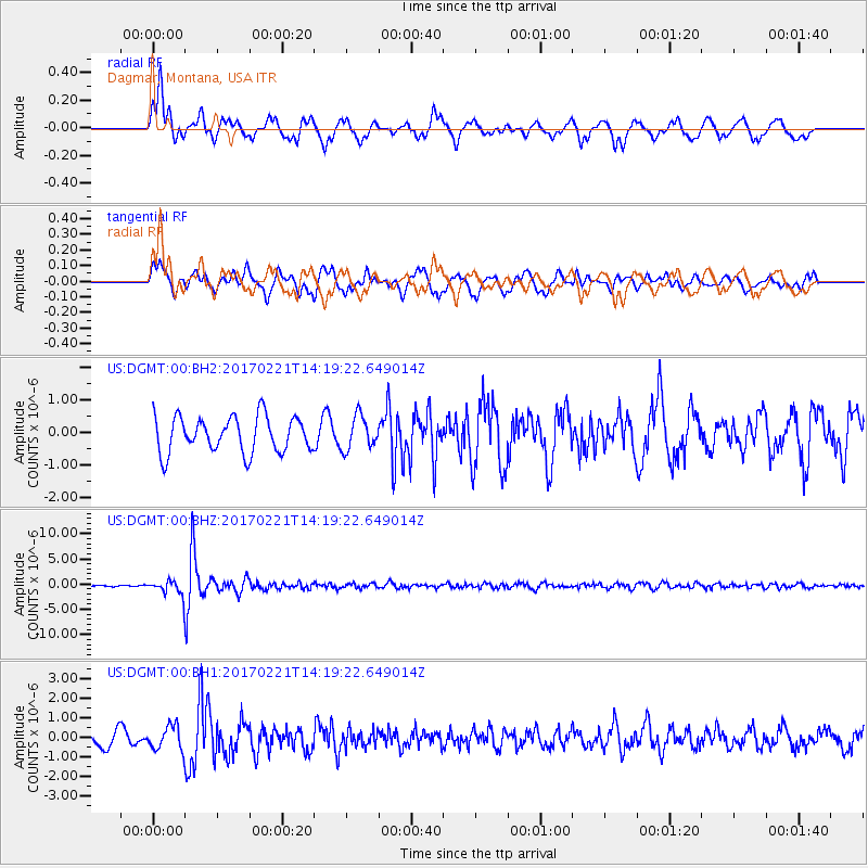
DGMT Dagmar, Montana, USA - Earthquake Result Viewer
*The percent match for this event was below the threshold and hence no stack was calculated.
| Earthquake location: |
Southern Bolivia |
| Earthquake latitude/longitude: |
-19.3/-63.9 |
| Earthquake time(UTC): |
2017/02/21 (052) 14:09:04 GMT |
| Earthquake Depth: |
598 km |
| Earthquake Magnitude: |
6.5 Mww |
| Earthquake Catalog/Contributor: |
NEIC PDE/us |
|
| Network: |
US United States National Seismic Network |
| Station: |
DGMT Dagmar, Montana, USA |
| Lat/Lon: |
48.47 N/104.20 W |
| Elevation: |
0.0 m |
|
| Distance: |
76.4 deg |
| Az: |
333.721 deg |
| Baz: |
141.067 deg |
| Ray Param: |
$rayparam |
*The percent match for this event was below the threshold and hence was not used in the summary stack. |
|
| Radial Match: |
63.05881 % |
| Radial Bump: |
400 |
| Transverse Match: |
70.578224 % |
| Transverse Bump: |
400 |
| SOD ConfigId: |
1992691 |
| Insert Time: |
2017-03-07 14:15:55.375 +0000 |
| GWidth: |
2.5 |
| Max Bumps: |
400 |
| Tol: |
0.001 |
|
Signal To Noise
| Channel | StoN | STA | LTA |
| US:DGMT:00:BHZ:20170221T14:19:22.649014Z | 7.1952405 | 1.4371627E-6 | 1.9973797E-7 |
| US:DGMT:00:BH1:20170221T14:19:22.649014Z | 1.6443061 | 6.15016E-7 | 3.7402768E-7 |
| US:DGMT:00:BH2:20170221T14:19:22.649014Z | 0.9304842 | 5.0643513E-7 | 5.442705E-7 |
| Arrivals |
| Ps | |
| PpPs | |
| PsPs/PpSs | |


