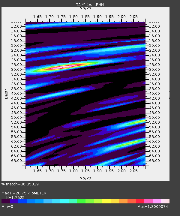
Y14A Wickenburg, AZ, USA - Earthquake Result Viewer
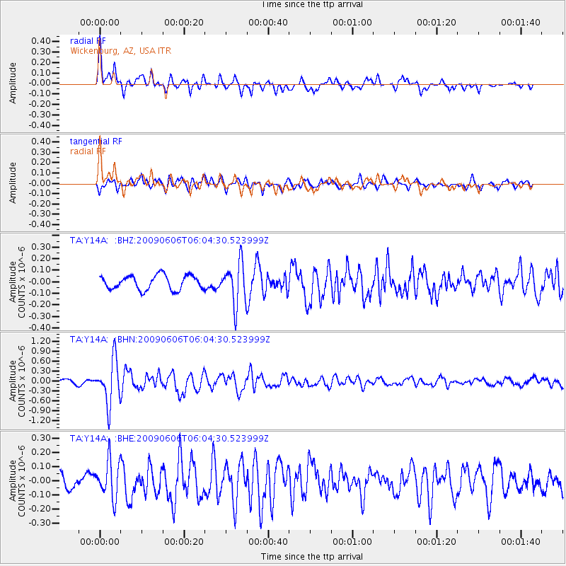
Earthquake location: Near East Coast Of Honshu, Japan
Earthquake latitude/longitude: 35.5/140.9
Earthquake time(UTC): 2009/06/06 (157) 05:52:43 GMT
Earthquake Depth: 34 km
Earthquake Magnitude: 5.8 MB, 5.4 MS, 5.8 MW, 5.7 MW
Earthquake Catalog/Contributor: WHDF/NEIC
Network: TA USArray Transportable Network (new EarthScope stations)
Station: Y14A Wickenburg, AZ, USA
Lat/Lon: 33.94 N/113.00 W
Elevation: 731 m
Distance: 82.3 deg
Az: 53.709 deg
Baz: 307.699 deg
Ray Param: 0.046905212
Estimated Moho Depth: 28.75 km
Estimated Crust Vp/Vs: 1.75
Assumed Crust Vp: 6.264 km/s
Estimated Crust Vs: 3.574 km/s
Estimated Crust Poisson's Ratio: 0.26
Radial Match: 86.85329 %
Radial Bump: 400
Transverse Match: 74.0793 %
Transverse Bump: 400
SOD ConfigId: 2648
Insert Time: 2010-03-07 05:15:44.314 +0000
GWidth: 2.5
Max Bumps: 400
Tol: 0.001

Signal To Noise

ChannelStoNSTALTA
TA:Y14A: :BHN:20090606T06:04:30.523999Z9.7902736.796606E-76.9422036E-8
TA:Y14A: :BHE:20090606T06:04:30.523999Z3.49405071.3714167E-73.925005E-8
TA:Y14A: :BHZ:20090606T06:04:30.523999Z3.05515071.8718085E-76.126731E-8
Arrivals
Ps3.5 SECOND
PpPs12 SECOND
PsPs/PpSs16 SECOND