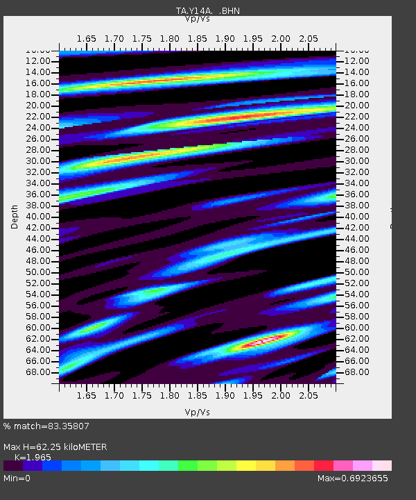
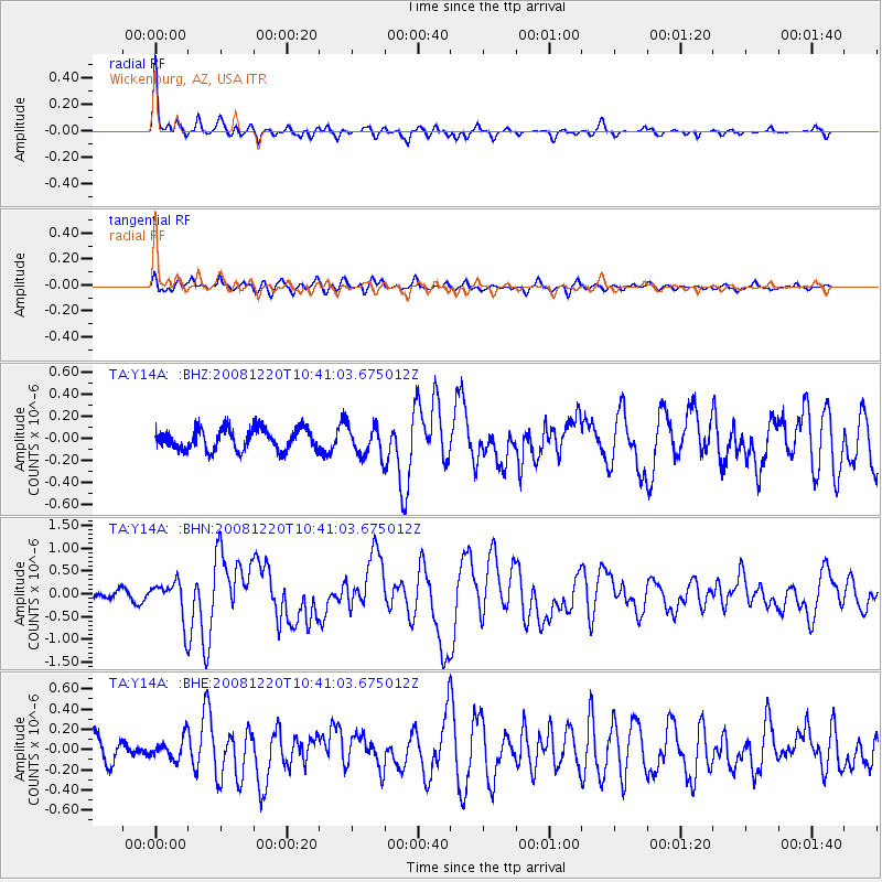
Y14A Wickenburg, AZ, USA - Earthquake Result Viewer

Earthquake location: Off East Coast Of Honshu, Japan
Earthquake latitude/longitude: 36.5/142.4
Earthquake time(UTC): 2008/12/20 (355) 10:29:23 GMT
Earthquake Depth: 19 km
Earthquake Magnitude: 6.0 MB, 6.3 MS, 6.3 MW, 6.3 MW
Earthquake Catalog/Contributor: WHDF/NEIC
Network: TA USArray Transportable Network (new EarthScope stations)
Station: Y14A Wickenburg, AZ, USA
Lat/Lon: 33.94 N/113.00 W
Elevation: 731 m
Distance: 80.7 deg
Az: 54.614 deg
Baz: 307.839 deg
Ray Param: 0.048059333
Estimated Moho Depth: 62.25 km
Estimated Crust Vp/Vs: 1.97
Assumed Crust Vp: 6.264 km/s
Estimated Crust Vs: 3.188 km/s
Estimated Crust Poisson's Ratio: 0.33
Radial Match: 83.35807 %
Radial Bump: 332
Transverse Match: 71.02427 %
Transverse Bump: 400
SOD ConfigId: 2658
Insert Time: 2010-03-07 05:15:45.954 +0000
GWidth: 2.5
Max Bumps: 400
Tol: 0.001

Signal To Noise

ChannelStoNSTALTA
TA:Y14A: :BHN:20081220T10:41:03.675012Z3.02865964.2174037E-71.3924983E-7
TA:Y14A: :BHE:20081220T10:41:03.675012Z0.85884351.04064476E-71.2116814E-7
TA:Y14A: :BHZ:20081220T10:41:03.675012Z1.42469911.3673768E-79.597654E-8
Arrivals
Ps9.8 SECOND
PpPs29 SECOND
PsPs/PpSs39 SECOND