You are here: Home > Network List > TA - USArray Transportable Network (new EarthScope stations) Stations List
> Station Y14A Wickenburg, AZ, USA > Earthquake Result Viewer
Y14A Wickenburg, AZ, USA - Earthquake Result Viewer

| Earthquake location: |
East Of Kuril Islands |
| Earthquake latitude/longitude: |
46.2/154.4 |
| Earthquake time(UTC): |
2006/12/07 (341) 19:10:21 GMT |
| Earthquake Depth: |
16 km |
| Earthquake Magnitude: |
6.3 MB, 6.1 MS, 6.3 MW, 6.3 MW |
| Earthquake Catalog/Contributor: |
WHDF/NEIC |
|
| Network: |
TA USArray Transportable Network (new EarthScope stations) |
| Station: |
Y14A Wickenburg, AZ, USA |
| Lat/Lon: |
33.94 N/113.00 W |
| Elevation: |
731 m |
|
| Distance: |
68.1 deg |
| Az: |
63.531 deg |
| Baz: |
311.539 deg |
| Ray Param: |
0.056520272 |
| Estimated Moho Depth: |
29.0 km |
| Estimated Crust Vp/Vs: |
1.76 |
| Assumed Crust Vp: |
6.264 km/s |
| Estimated Crust Vs: |
3.554 km/s |
| Estimated Crust Poisson's Ratio: |
0.26 |
|
| Radial Match: |
89.49082 % |
| Radial Bump: |
400 |
| Transverse Match: |
76.59334 % |
| Transverse Bump: |
400 |
| SOD ConfigId: |
2564 |
| Insert Time: |
2010-03-07 05:15:52.292 +0000 |
| GWidth: |
2.5 |
| Max Bumps: |
400 |
| Tol: |
0.001 |
|
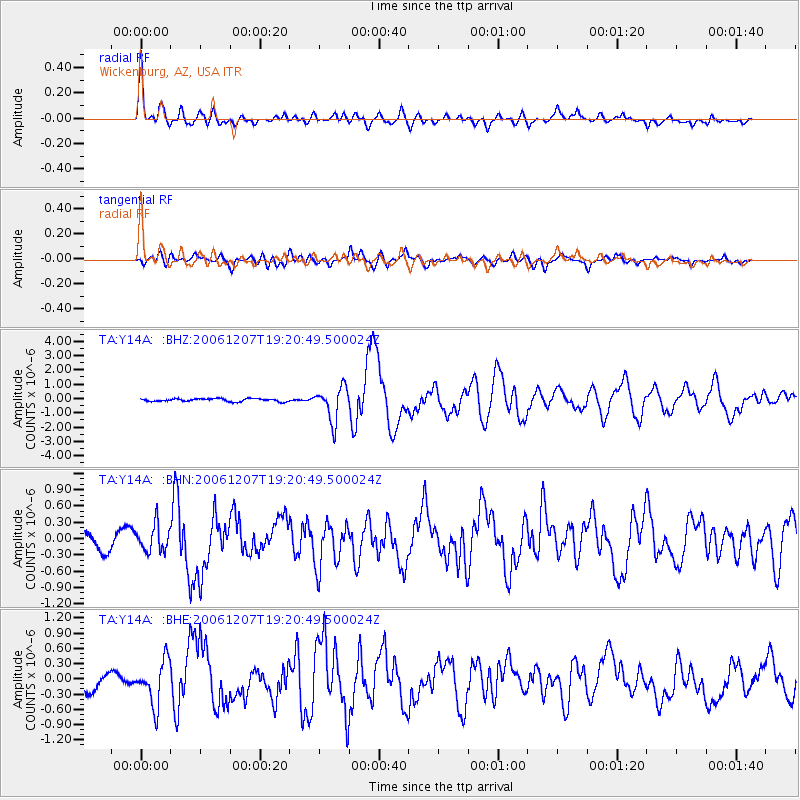
Signal To Noise
| Channel | StoN | STA | LTA |
| TA:Y14A: :BHN:20061207T19:20:49.500024Z | 1.3355298 | 2.4059025E-7 | 1.8014593E-7 |
| TA:Y14A: :BHE:20061207T19:20:49.500024Z | 2.7434402 | 4.2963012E-7 | 1.5660271E-7 |
| TA:Y14A: :BHZ:20061207T19:20:49.500024Z | 11.737041 | 1.1771926E-6 | 1.0029722E-7 |
| Arrivals |
| Ps | 3.7 SECOND |
| PpPs | 12 SECOND |
| PsPs/PpSs | 16 SECOND |


