You are here: Home > Network List > TA - USArray Transportable Network (new EarthScope stations) Stations List
> Station Y14A Wickenburg, AZ, USA > Earthquake Result Viewer
Y14A Wickenburg, AZ, USA - Earthquake Result Viewer
| Earthquake location: |
Mariana Islands |
| Earthquake latitude/longitude: |
21.0/144.7 |
| Earthquake time(UTC): |
2007/01/30 (030) 21:37:45 GMT |
| Earthquake Depth: |
30 km |
| Earthquake Magnitude: |
6.3 MB, 6.5 MS, 6.6 MW, 6.5 MW |
| Earthquake Catalog/Contributor: |
WHDF/NEIC |
|
| Network: |
TA USArray Transportable Network (new EarthScope stations) |
| Station: |
Y14A Wickenburg, AZ, USA |
| Lat/Lon: |
33.94 N/113.00 W |
| Elevation: |
731 m |
|
| Distance: |
88.1 deg |
| Az: |
54.362 deg |
| Baz: |
294.006 deg |
| Ray Param: |
0.042767346 |
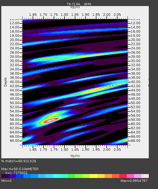
| Estimated Moho Depth: |
58.0 km |
| Estimated Crust Vp/Vs: |
1.74 |
| Assumed Crust Vp: |
6.264 km/s |
| Estimated Crust Vs: |
3.605 km/s |
| Estimated Crust Poisson's Ratio: |
0.25 |
|
| Radial Match: |
88.931526 % |
| Radial Bump: |
342 |
| Transverse Match: |
72.52263 % |
| Transverse Bump: |
400 |
| SOD ConfigId: |
2564 |
| Insert Time: |
2010-03-07 05:15:59.722 +0000 |
| GWidth: |
2.5 |
| Max Bumps: |
400 |
| Tol: |
0.001 |
|

Signal To Noise
| Channel | StoN | STA | LTA |
| TA:Y14A: :BHN:20070130T21:50:02.374006Z | 1.7089158 | 4.6791635E-7 | 2.738089E-7 |
| TA:Y14A: :BHE:20070130T21:50:02.374006Z | 4.607023 | 7.963725E-7 | 1.7286054E-7 |
| TA:Y14A: :BHZ:20070130T21:50:02.374006Z | 6.937028 | 2.1495455E-6 | 3.098655E-7 |
| Arrivals |
| Ps | 7.0 SECOND |
| PpPs | 25 SECOND |
| PsPs/PpSs | 32 SECOND |


