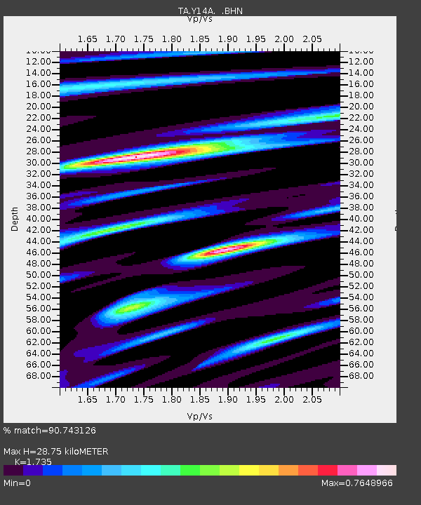
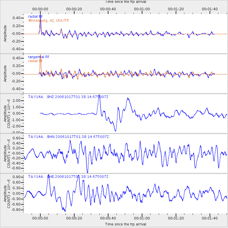
Y14A Wickenburg, AZ, USA - Earthquake Result Viewer

Earthquake location: New Britain Region, P.N.G.
Earthquake latitude/longitude: -5.9/151.0
Earthquake time(UTC): 2006/10/17 (290) 01:25:12 GMT
Earthquake Depth: 32 km
Earthquake Magnitude: 6.4 MB, 6.9 MS, 6.7 MW, 6.6 MW
Earthquake Catalog/Contributor: WHDF/NEIC
Network: TA USArray Transportable Network (new EarthScope stations)
Station: Y14A Wickenburg, AZ, USA
Lat/Lon: 33.94 N/113.00 W
Elevation: 731 m
Distance: 98.2 deg
Az: 56.658 deg
Baz: 268.454 deg
Ray Param: 0.03995022
Estimated Moho Depth: 28.75 km
Estimated Crust Vp/Vs: 1.74
Assumed Crust Vp: 6.264 km/s
Estimated Crust Vs: 3.61 km/s
Estimated Crust Poisson's Ratio: 0.25
Radial Match: 90.743126 %
Radial Bump: 400
Transverse Match: 72.80018 %
Transverse Bump: 400
SOD ConfigId: 2665
Insert Time: 2010-03-07 05:16:18.433 +0000
GWidth: 2.5
Max Bumps: 400
Tol: 0.001

Signal To Noise

ChannelStoNSTALTA
TA:Y14A: :BHN:20061017T01:38:14.675007Z0.499592757.679168E-81.5370856E-7
TA:Y14A: :BHE:20061017T01:38:14.675007Z2.7890343.3267867E-71.1928097E-7
TA:Y14A: :BHZ:20061017T01:38:14.675007Z13.8061991.010824E-67.3215226E-8
Arrivals
Ps3.4 SECOND
PpPs12 SECOND
PsPs/PpSs16 SECOND