You are here: Home > Network List > US - United States National Seismic Network Stations List
> Station LRAL Lakeview Retreat, Alabama, USA > Earthquake Result Viewer
LRAL Lakeview Retreat, Alabama, USA - Earthquake Result Viewer
| Earthquake location: |
Southern Bolivia |
| Earthquake latitude/longitude: |
-19.3/-63.9 |
| Earthquake time(UTC): |
2017/02/21 (052) 14:09:04 GMT |
| Earthquake Depth: |
598 km |
| Earthquake Magnitude: |
6.5 Mww |
| Earthquake Catalog/Contributor: |
NEIC PDE/us |
|
| Network: |
US United States National Seismic Network |
| Station: |
LRAL Lakeview Retreat, Alabama, USA |
| Lat/Lon: |
33.03 N/87.00 W |
| Elevation: |
130 m |
|
| Distance: |
56.5 deg |
| Az: |
336.726 deg |
| Baz: |
153.62 deg |
| Ray Param: |
0.061556775 |
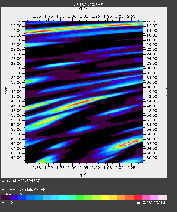
| Estimated Moho Depth: |
61.75 km |
| Estimated Crust Vp/Vs: |
2.04 |
| Assumed Crust Vp: |
6.565 km/s |
| Estimated Crust Vs: |
3.226 km/s |
| Estimated Crust Poisson's Ratio: |
0.34 |
|
| Radial Match: |
91.806335 % |
| Radial Bump: |
400 |
| Transverse Match: |
73.18014 % |
| Transverse Bump: |
400 |
| SOD ConfigId: |
1992691 |
| Insert Time: |
2017-03-07 14:16:27.228 +0000 |
| GWidth: |
2.5 |
| Max Bumps: |
400 |
| Tol: |
0.001 |
|
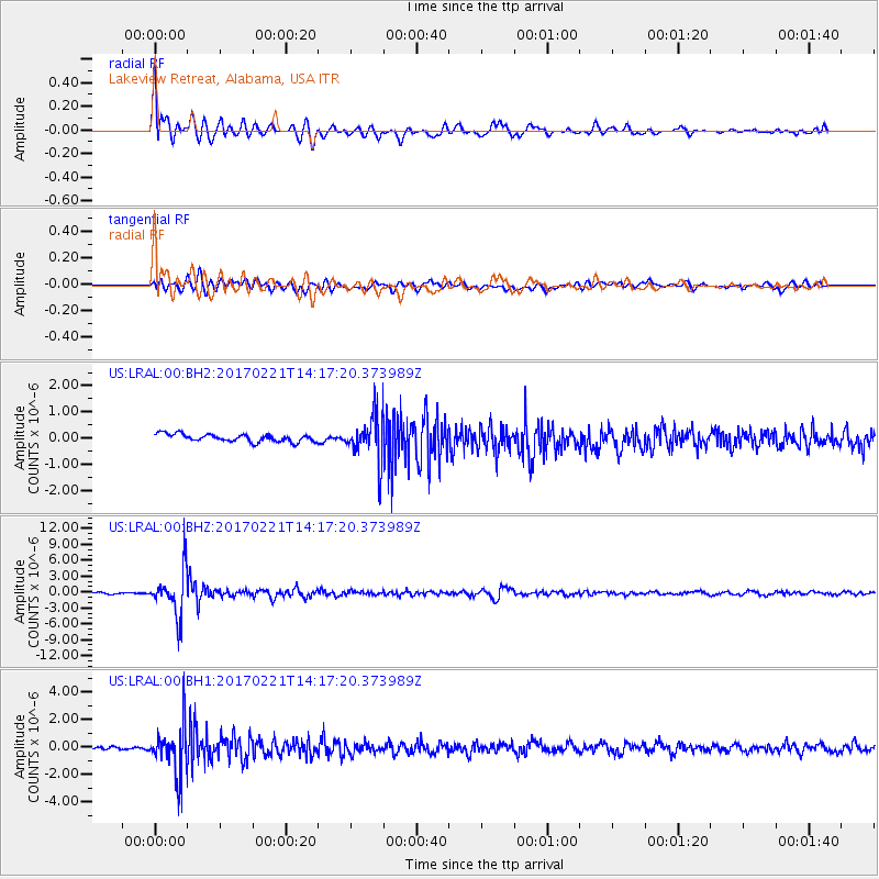
Signal To Noise
| Channel | StoN | STA | LTA |
| US:LRAL:00:BHZ:20170221T14:17:20.373989Z | 28.418291 | 4.1230846E-6 | 1.450856E-7 |
| US:LRAL:00:BH1:20170221T14:17:20.373989Z | 22.493582 | 1.7992435E-6 | 7.998919E-8 |
| US:LRAL:00:BH2:20170221T14:17:20.373989Z | 5.697339 | 8.313272E-7 | 1.45915E-7 |
| Arrivals |
| Ps | 10 SECOND |
| PpPs | 27 SECOND |
| PsPs/PpSs | 38 SECOND |


